flying_hun
Adverse Selection
- Joined
- May 4, 2005
- Location
- Orinda, CA
- Moto(s)
- A funky red & white Italian named Gianni Cervo! Versys - two of 'em! And an Enfield for laughs.
- BARF perks
- AMA #: 281672
Some years back my sister emigrated to Canada, where she lives in the interior of British Columbia (directions: Go to Prince George, turn left, ride three hours, you're there), and July was intended to be my annual visit. Their region in BC had an unusually dry winter since all the rain came down here, and as I was getting ready to leave, she told me that they were being threatened by fires. We agreed that we'd do a go/no-go before I crossed the border.
My goal was to get to the border by interesting routes, and stop in my old stomping grounds of South King County Washington, and to visit with my best friends from college, Jamie and Mary en route. In June, Jamie had a landmark birthday, so I had driven up there and scouted some routes. On that trip, I decided that in addition to being boring, that Hwy 97 was too crowded too. On the way back, I explored some of eastern Oregon, eventually getting to Hwy 395, and decided that I wanted to come back on the bike. One of the geological features that really knocked me out on that trip was the Abert Rim just north of Lakeville, OR. I'd been there before, but on the June trip I got snowed on!
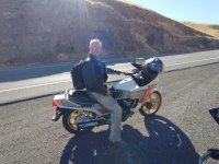
I left Orinda on a Wednesday morning at the crack of 9:45 with the goal of getting some miles under my wheels, but not for it to be an stupid boring day. So after getting off the freeway to ride Pleasants Valley up towards Winters, I made my way to Chico, then up Hwy 32 to gain some altitude. The last time I'd been on 32 was during a BARF rally, and I was riding with Banjoboy, so that must have been at least ten years ago. Great road, but.... Well, there was construction, but worse than than, there was a long convoy of tree service trucks towing woodchippers. Just in case you're wondering, Mountain F Enterprises. I bring this up because these guys are exemplars of why passing zones often don't work as intended. Where it was not possible to pass, these guys could not get within a country mile of the posted limit, but as soon as they saw a sign saying "Passing Zone Ahead", each of the drivers suddenly remembered that they're the love children of Mario Andretti and Shirley Muldowney, and while they'd stay in the right lane, the hammer would be all the way down, and cagers would pull out but not be able to complete the pass.
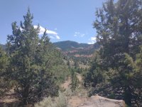
By the time I got to Susanville I was still pissed off by the traffic, and didn't bother to stop for fuel, turning towards Alturas on 395. About 25 miles or so outside of Alturas, my fuel gauge dropped to the last bar. Oops! No fuel between Susanville and Alturas! I'd never run the tank down that far, and had no idea how far I could go. I dropped speed and nursed it, cursing my impatience for not getting fuel when I could. It was a very long 25 miles as I contemplated running out of gas on a very empty road, but in the end I got into Alturas just fine, and when I filled it up, it only took a whiff over four gallons (allegedly it holds five) with 200 miles on the trip odo. Oh well, now I know it will do at least 200 on a tank.
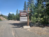
As I crossed into Oregon, there was a little campground right by the border, and it looked nice. I rolled back out to the little settlement nearby to find a store with something cold to drink, but there was little around, so I continued up to Lakeville where I grabbed dinner. While eating dinner, I did a search on Google maps to see if there were other campgrounds around, and it showed several NFS
campgrounds in the hills above town, so I went looking.
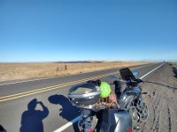
If lesson #1 of the day was to get gas when and where you can, lesson #2 was don't trust Google navigation on Forest Service roads. I approached a 5 way intersection, and navigation said, "slight left". I took what I thought was a slight left, but apparently I should have gone further left. Rather than telling me to turn around, it rerouted me to an intersection several miles up the road. When I got there it said I was further from the destination than I had been at the prior intersection, and it tried to turn me down a "road" that was overgrown with brush. I turned the other way, and Google approved of that choice, but then the road was blocked with downed trees. Nothing to do but turn around. Did I mention it was getting dark? Bailout time! Back to the paved road just as the sun disappeared below the horizon.
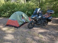
After dealing with a completely unhelpful desk clerk at the local Best Western, I stayed a place called the Fremont Inn. It was a good place. So ended day 1, no pics, but a fair number of miles under my wheels.
To be continued. More pics tomorrow.
My goal was to get to the border by interesting routes, and stop in my old stomping grounds of South King County Washington, and to visit with my best friends from college, Jamie and Mary en route. In June, Jamie had a landmark birthday, so I had driven up there and scouted some routes. On that trip, I decided that in addition to being boring, that Hwy 97 was too crowded too. On the way back, I explored some of eastern Oregon, eventually getting to Hwy 395, and decided that I wanted to come back on the bike. One of the geological features that really knocked me out on that trip was the Abert Rim just north of Lakeville, OR. I'd been there before, but on the June trip I got snowed on!
I left Orinda on a Wednesday morning at the crack of 9:45 with the goal of getting some miles under my wheels, but not for it to be an stupid boring day. So after getting off the freeway to ride Pleasants Valley up towards Winters, I made my way to Chico, then up Hwy 32 to gain some altitude. The last time I'd been on 32 was during a BARF rally, and I was riding with Banjoboy, so that must have been at least ten years ago. Great road, but.... Well, there was construction, but worse than than, there was a long convoy of tree service trucks towing woodchippers. Just in case you're wondering, Mountain F Enterprises. I bring this up because these guys are exemplars of why passing zones often don't work as intended. Where it was not possible to pass, these guys could not get within a country mile of the posted limit, but as soon as they saw a sign saying "Passing Zone Ahead", each of the drivers suddenly remembered that they're the love children of Mario Andretti and Shirley Muldowney, and while they'd stay in the right lane, the hammer would be all the way down, and cagers would pull out but not be able to complete the pass.
By the time I got to Susanville I was still pissed off by the traffic, and didn't bother to stop for fuel, turning towards Alturas on 395. About 25 miles or so outside of Alturas, my fuel gauge dropped to the last bar. Oops! No fuel between Susanville and Alturas! I'd never run the tank down that far, and had no idea how far I could go. I dropped speed and nursed it, cursing my impatience for not getting fuel when I could. It was a very long 25 miles as I contemplated running out of gas on a very empty road, but in the end I got into Alturas just fine, and when I filled it up, it only took a whiff over four gallons (allegedly it holds five) with 200 miles on the trip odo. Oh well, now I know it will do at least 200 on a tank.
As I crossed into Oregon, there was a little campground right by the border, and it looked nice. I rolled back out to the little settlement nearby to find a store with something cold to drink, but there was little around, so I continued up to Lakeville where I grabbed dinner. While eating dinner, I did a search on Google maps to see if there were other campgrounds around, and it showed several NFS
campgrounds in the hills above town, so I went looking.
If lesson #1 of the day was to get gas when and where you can, lesson #2 was don't trust Google navigation on Forest Service roads. I approached a 5 way intersection, and navigation said, "slight left". I took what I thought was a slight left, but apparently I should have gone further left. Rather than telling me to turn around, it rerouted me to an intersection several miles up the road. When I got there it said I was further from the destination than I had been at the prior intersection, and it tried to turn me down a "road" that was overgrown with brush. I turned the other way, and Google approved of that choice, but then the road was blocked with downed trees. Nothing to do but turn around. Did I mention it was getting dark? Bailout time! Back to the paved road just as the sun disappeared below the horizon.
After dealing with a completely unhelpful desk clerk at the local Best Western, I stayed a place called the Fremont Inn. It was a good place. So ended day 1, no pics, but a fair number of miles under my wheels.
To be continued. More pics tomorrow.


 So, turn around I did. Stopping at an old school service station, where I had my first chatting with strangers experience. The attendant and I had a great chat. I guess on day 1 I was too focused on making time to stop to chat, and chatting with strangers is one of the very best things about long road trips.


 What a great idea!


 I knew there was a
 It had a legendary silver dollar bar, a dance floor, and it attracted an interesting mix of clientele; loggers, miners, truck drivers, cowgirls, hippies, and bikers. Fights were common. One Labor Day I was there when one of the cowgirls rode her horse into the bar. It was a wild place! If you remember the old Jimmy Buffett song, Livingston Saturday Night, that about sums it up.


 I began looking for fuel before leaving the freeway, and at a place called Arlington I found a Shell station where I stopped for some Gatorade, iced coffee, and a bite to eat. When I got to the counter to pay for it the cashier took one look at me and said, "I want you to go stand in the cooler until you feel better. I don't need a heat emergency today." I was dripping with sweat and bright red in color. It was a good call.