-
There has been a recent cluster of spammers accessing BARFer accounts and posting spam. To safeguard your account, please consider changing your password. It would be even better to take the additional step of enabling 2 Factor Authentication (2FA) on your BARF account. Read more here.
You are using an out of date browser. It may not display this or other websites correctly.
You should upgrade or use an alternative browser.
You should upgrade or use an alternative browser.
Photos of your bike on location
- Thread starter Gary856
- Start date


ratpick
Well-known member

ratpick
Well-known member
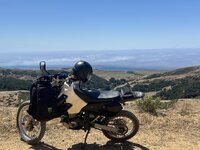
Stopped by the “Carmel Riviera” , nice spot to reflect on a nice ride.


Gary856
Are we having fun yet?
- Joined
- Apr 6, 2009
- Location
- San Jose, CA
- Moto(s)
- WR250F, MTS1200, 950SM, FZ1, DR650, R1250GS
- Name
- Gary
Pescadero


two wheel tramp
Budman's Favorite
- Joined
- Dec 28, 2010
- Location
- your mom’s house
- Moto(s)
- DR650, X2!, TTR250, 790 ADV S, 950 SM-R, 89 Transalp, TTR2Fiddy
- Name
- Triple R
- BARF perks
- AMA #2771957

Lonster
GaMMa RaNGeR
- Joined
- Jan 21, 2003
- Location
- The Emerald Triangle
- Moto(s)
- 1986 RG500 Gamma, 2020 KTM 890 Duke R, 1975 RD400 AHRMA Special, 1975 CB350f
- Name
- Lonster
- BARF perks
- AMA #: 305491
Plane Gray and Lonster on top of South Fork mountain, headed to the HoHo Rally.

- Joined
- Apr 4, 2002
- Location
- Menlo Park, Ca.
- Moto(s)
- Keep me rocking life
- Name
- Budman
- BARF perks
- AMA Life Member #203453
Went to Weaverville for the Hoho Rally.
Riding with a big group meant limited photo opportunities, but when you get to the Motel... bam.

Riding with a big group meant limited photo opportunities, but when you get to the Motel... bam.
CDONA
Home of Vortex tuning
- Joined
- Jul 30, 2010
- Moto(s)
- Triumph scrambler, TW200, Monkey
- Name
- # 44659
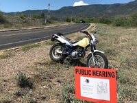
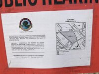
Found this, 1/2 block from my driveway, end of airport runway, mixed in with campaign signage
A zoning change to allow a conditional permit to run cattle, on this spot.
Is this still done this way in Ca. ??
That search light, reminds me of "The Burning Man" big ol' light (seeing eye) rotating with the two red lit antenna ears for the head shape.
I am truly home, here.
A zoning change to allow a conditional permit to run cattle, on this spot.
Is this still done this way in Ca. ??
That search light, reminds me of "The Burning Man" big ol' light (seeing eye) rotating with the two red lit antenna ears for the head shape.
I am truly home, here.
Attachments
Gary856
Are we having fun yet?
- Joined
- Apr 6, 2009
- Location
- San Jose, CA
- Moto(s)
- WR250F, MTS1200, 950SM, FZ1, DR650, R1250GS
- Name
- Gary
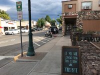
Armsby Ln. Rode past this road a hundred times and thought it would dead end in a hundred yards, so never checked it out until today. Big surprise and ended up on a hilltop.

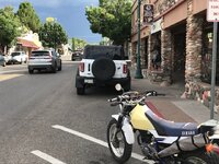
McKean Rd

McKean Rd
Last edited:
CDONA
Home of Vortex tuning
- Joined
- Jul 30, 2010
- Moto(s)
- Triumph scrambler, TW200, Monkey
- Name
- # 44659
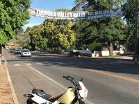
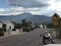
Rally in Cottonwood, Ya, all invited. Cliff Castle Casino sponsors it.
Downtown Cottonwood, Az has wineries, I remember when Paso Robles WAS a cattle town,
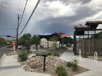
Merkin invested here downtown, pix forthcoming
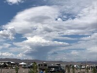
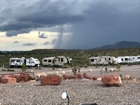
Little monsoon weather
Downtown Cottonwood, Az has wineries, I remember when Paso Robles WAS a cattle town,
Merkin invested here downtown, pix forthcoming
Little monsoon weather
Attachments
CDONA
Home of Vortex tuning
- Joined
- Jul 30, 2010
- Moto(s)
- Triumph scrambler, TW200, Monkey
- Name
- # 44659
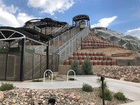
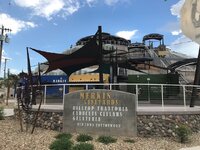
Az. wineries, showing off here in downtown Cottonwood, starting the wine revolution?
This place went in as a big surprise to me, took an old gnarly knob, into a show place, that tram to the top, so Sterling, , ,
So many different tasting locations in the area, from Page Springs, vineyards, to winery store fronts in Jerome, Cottonwood, Clarksdale, Sedona,
This place went in as a big surprise to me, took an old gnarly knob, into a show place, that tram to the top, so Sterling, , ,
So many different tasting locations in the area, from Page Springs, vineyards, to winery store fronts in Jerome, Cottonwood, Clarksdale, Sedona,
Attachments
Last edited:
CDONA
Home of Vortex tuning
- Joined
- Jul 30, 2010
- Moto(s)
- Triumph scrambler, TW200, Monkey
- Name
- # 44659
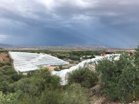
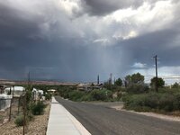
Had a bit o' weather slowly arriving, left the rig @ quarter to five, had dinner, then these pix.
Rain didn't hit me until 8:30 that nite, rain is about 5 miles away.
Mingus, clear to the south.
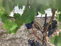
Good sized grapes, haven't seen this level of vine protection, wasn't here last year.
I figure, bugs, birds, or sun burn SPF, but hold the camera close to the net, to get a peek.
Rain didn't hit me until 8:30 that nite, rain is about 5 miles away.
Mingus, clear to the south.
Good sized grapes, haven't seen this level of vine protection, wasn't here last year.
I figure, bugs, birds, or sun burn SPF, but hold the camera close to the net, to get a peek.
Attachments
GAJ
Well-known member
Visited Cottonwood several times when my sister in law lived there.
Nice tiny little town.
The heat, driving distances and relative isolation got to her and her future husband so they moved back here within a mile of here.
Some of the wineries we visited, one of them owned by Maynard, the TOOL vocalist, used California grapes.
Nice tiny little town.
The heat, driving distances and relative isolation got to her and her future husband so they moved back here within a mile of here.
Some of the wineries we visited, one of them owned by Maynard, the TOOL vocalist, used California grapes.
CDONA
Home of Vortex tuning
- Joined
- Jul 30, 2010
- Moto(s)
- Triumph scrambler, TW200, Monkey
- Name
- # 44659
I know some of the older wineries are shipping in grapes, from out of state.
Time on the road, bouncing, does start the crush, little control there, but processed upon arrival.
Blending was getting started (new business) in a big way in Paso last year, I tried a Firestone _Walker xmas beer, blended from three different holiday brews. Same people doing wine, so many flavors, imagination required, sky is the limit.
N4teTheGreat
FknN8
- Joined
- Dec 5, 2009
- Location
- San Francisco
- Moto(s)
- 2012 DRZ 400s, 2018 Ducati Hypermotard SP, 2008 KTM 950 SM
- Name
- Nathan
New tires for the Ducati compliments of Motolucia, I'm running out of excuses, guess I'm gonna go see what Alaska is like in the fall...

ScottRNelson
Mr. Dual Sport Rider
Hells Canyon
Hells Canyon is the border between Idaho and Oregon. It used to just be the Snake River going through there but they built three dams along it for power generation: Brownlee in 1959, Oxbow in 1961, and Hells Canyon in 1967. They were considering building one HUGE dam at the end where Hells Canyon Dam is at, but decided against it.
I try to ride to Hells Canyon once a year, but it's been two years since my previous trip. Once you drop down into the canyon there are some truly wonderful twisty roads - at least on the Idaho side. We had a bit of light rain heading down to the water, then it dried up and gave us some fantastic riding.
Hells Canyon along Oxbow Reservoir

This is the only turnout with a view in the 70 miles from Cambridge, ID to the end of the road.

On Hells Canyon Dam looking toward the end of the road down there where it gets too steep to have a road.

This is Hells Canyon Dam, opened in 1967.

After the three dams the Snake River turns back into a regular river. They do raft trips and jet boat cruises from here.

Looking back up the road from the visitor center parking lot at the end of the road.

Hells Canyon is the border between Idaho and Oregon. It used to just be the Snake River going through there but they built three dams along it for power generation: Brownlee in 1959, Oxbow in 1961, and Hells Canyon in 1967. They were considering building one HUGE dam at the end where Hells Canyon Dam is at, but decided against it.
I try to ride to Hells Canyon once a year, but it's been two years since my previous trip. Once you drop down into the canyon there are some truly wonderful twisty roads - at least on the Idaho side. We had a bit of light rain heading down to the water, then it dried up and gave us some fantastic riding.
Hells Canyon along Oxbow Reservoir
This is the only turnout with a view in the 70 miles from Cambridge, ID to the end of the road.
On Hells Canyon Dam looking toward the end of the road down there where it gets too steep to have a road.
This is Hells Canyon Dam, opened in 1967.
After the three dams the Snake River turns back into a regular river. They do raft trips and jet boat cruises from here.
Looking back up the road from the visitor center parking lot at the end of the road.
- Joined
- Apr 4, 2002
- Location
- Menlo Park, Ca.
- Moto(s)
- Keep me rocking life
- Name
- Budman
- BARF perks
- AMA Life Member #203453
Looks awesome Scott! That last pic has my mouth watering.


stratslingr77
Active member
That's a fun road!Hells Canyon
Hells Canyon is the border between Idaho and Oregon. It used to just be the Snake River going through there but they built three dams along it for power generation: Brownlee in 1959, Oxbow in 1961, and Hells Canyon in 1967. They were considering building one HUGE dam at the end where Hells Canyon Dam is at, but decided against it.
I try to ride to Hells Canyon once a year, but it's been two years since my previous trip. Once you drop down into the canyon there are some truly wonderful twisty roads - at least on the Idaho side. We had a bit of light rain heading down to the water, then it dried up and gave us some fantastic riding.
Hells Canyon along Oxbow Reservoir
This is the only turnout with a view in the 70 miles from Cambridge, ID to the end of the road.
On Hells Canyon Dam looking toward the end of the road down there where it gets too steep to have a road.
This is Hells Canyon Dam, opened in 1967.
After the three dams the Snake River turns back into a regular river. They do raft trips and jet boat cruises from here.
Looking back up the road from the visitor center parking lot at the end of the road.