• There has been a recent cluster of spammers accessing BARFer accounts and posting spam. To safeguard your account, please consider changing your password. It would be even better to take the additional step of enabling 2 Factor Authentication (2FA) on your BARF account. Read more here.

Boonies Tour '24

twinstar

Member
Joined
Dec 10, 2019
Location
East Bay
Moto(s)
KLR650
(and slowly rehabbing a '70 CB175)
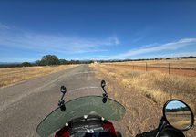
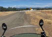
I just got home from a 20 day solo trip to Northern Cal and Southern Oregon. 15 days of riding, 5 days of relaxing (or fixing the moto). My longest trip by far (2.2K miles), and found some pretty remote and interesting areas (especially for a Geologist). Ended up boiling the radiator on Anaktuvuk Saddle, which became the northern terminus of the trip lol. Ill post more details in the coming days, but wanted to start this thread to motivate me to keep documenting the rest. I had an absolute blast!

I put away all the gear yesterday, and today I combined all the gpx files into one place.

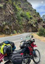
Feather River Canyon (not long before two fighter jets flew by, awesome!)
2 bridges.jpg

NorthSouth.jpg
Note: I know someone in the Ave of the Giants area, so that became something of a central hub. Also have a buddy in Weed that graciously allowed me to stay a few days while I recovered from the radiator event (note to self: convert the fan fuse to a blade so I only need to carry one type of spare)
Northbound Table.jpg

Southbound Table.jpg

Probably overpacked a bit, but feeling pretty good overall about the kit
gear.jpg

Counties:

Rivers:
 
Last edited:
Awesome, and I love the breakdown of the trip and the gear weights.
 
Good stuff twinstar... and yes... do moar!!!!
 
Day 1 - and thoughts about Navigation

Leading up to this trip was an exceptionally busy time at work, so I didn't do any route planning other than decide to head north. I arranged to spend the first few days with a friend near the Ave of the Giants, and given that "The Ave" is nearly 300 miles from home, I booked the first night roughly half way at Hendy Woods State Park.

A few days prior to departure I mapped a route using Rever's "Twisty Routing" tool (available with the paid version), and it picked some nice roads; including Mt Veeder Rd outside of Napa. Mt Veeder is popular with the bicycle crowd and I found it very enjoyable.
1719621715107.png

By contrast, here is the Google Maps (Avoid Highways) offering:
1719621887043.png

So, in this case, Rever picked a fantastic route that I would not likely have picked myself, short of doing a ton of research ahead of time.

BUT: A about a week later, Rever sent me miles down a dirt road which ended at a private property sign (where I turned around). And, the routing options (and possibly even turn by turn navigation) only work when online; which meant it was a no go for most of my trip. Additionally, even though my location was shown accurately in the rever app all of Day 1; my gpx recording was missing large sections. That night I did change some battery settings in phone that I use for track recording which may have fixed it; but I didnt trust Rever again to record. So, in the end, Rever was good for route planning when I had service; but I did not figure out how to download all the maps ahead of time so really wasn't too useful unless I had good service lol.

Here is another example of routing differences between different apps from Day 2, where I wanted to hit the coast first, then make my way up to Ave of the Giants:

Rever Option:
1719622676991.png

Google Maps (Avoid Highway)
1719622829812.png

And the route I took after I noticed on the Butler paper map that the Philo Greenwood Rd was paved (and I loved it!):
1719622966220.png

So, in the end I used this "Rugged" Android Phone (with no SIM card, but a $16 Terabyte SD card) primarily to record the ride, and occasionally for turn by turn Nav; combined with DMD2 software which I really like. Currently DMD works best for Nav if you have an existing GPX to follow; but not so great if making it up as you go along. So given that I had limited/no cell service most of the time, I did most of my route planning the night before via map (or phone), and then go via dead reckoning during the day (e.g. no turn by turn nav) using paper maps, or other nav software (google maps) on my iPhone. Some other nav tools I used were Google Maps, Gaia, OSMand, and CalTopo. I downloaded most of maps for Northern Cal and Oregon to both the droid and my iPhone before I left which worked great. Also, I used Google Maps A LOT, to get from town to town; a very cool feature is that Search and Navigation works OFFLINE as long as you download the maps ahead of time - pretty amazing. I also used this android tablet - but I didn't download enough maps to it ahead of time so I used it mostly for keeping a diary of sorts. The tablet was snappy, good battery life and came with a super thin keyboard that actually worked lol.

1719623113099.png
 
Last edited:
Day 2 - Hendy Woods SP to the Avenue of the Giants (147 miles)

Camp (nice campground)
1720308491806.png

Did a short hike to see the former home of the Hendy Hermit. Then took the Philo Greenwood Rd from the campground to the coast. Highway 1 as beautiful and nearly deserted.
1720309750741.png

Somewhere Along The Avenue
1720310219839.png
1720310051005.png
 
Day 4, First half of a Loop from The Ave to Mattole Beach Campgroup (red track) and back (blue track) (132 miles for the loop)

1720313794945.png

Took Mattole Rd from Ave of the Giants, stopping at the Big Tree day use area to check out The Champion Coast Redwood before Albee Creek CG. Left all the gear on the covered bike, np. Meet a few different parties from Oregon and they gave me some tips of places to go. Continued on to the Coast via Mattole, potholed but fun. Got something to drink in Honeydew after crossing a wood roadway bridge. Went the wrong way out of Honeydew but DMD quickly sorted me out. Was using native DMD routing and it worked great. Took lighthouse Rd towards the Mattole CG and it quickly turned to small gravel, but then came across a washout repaired with golfball size gravel. I parked the bike and walked it a bit, determining it was only about 100 yards long, so I continued on. The cg is first come first sever and the next viable option is quite a way away (Ferndale), fortunately there were plenty of spaces. It was early afternoon and I decided to stay. After scoping out the sites I picked one of the few with any shade (#1). A group of packpackers got dropped off and headed out south, reminded me of when I went packpacking here decades ago. The beach was miles long with massive waves and nobody around, highly recommend this campground (and only 15 bucks..cash..BLM..and no water).

The gear
1720314323601.png

Not a true Boonies Tour without a beater RV (on Mattole Rd)
1720314395039.png

The Honeydew Creek Bridge
1720314444267.png

Stopped for a snack in Honeydew
1720314648162.png

Passed a Grange - I wonder if they have pancake breakfasts like the one I used to go to growing up
1720314734860.png

Lighthouse Rd on the way to Mattole Beach Campground
1720314894132.png

1720314942135.png

Shoutout to this electric pump for filling my sleeping pad - awesome!
1720314996241.png

1720315090281.png
 
Day 5

Next morning I was on the road by 9:15 and continued along Mattole Rd, after stopping for some water in Petrolia. Mattole Rd hugs the shore a bit then steeply climbs up and over. Several sections were washed out with gravel repair. In Ferndale I visited the museum a guy in Petrolia told me about, probably spent an hour with the docent. Highly recommend. Ferndale used to make butter and invented wrapping butter in paper so it could be shipped to SF in two air tight boxes (on schooners!). I continued back to “The Avenue” along Grizzly Bluff Rd.

Never would have guess this:
1720315550860.png

1720315658309.png

1720315852337.png

1720315896463.png

The Eel River (pic taken along Blue Slide Road)
1720315936614.png

Vertical Pano
1720316154678.png
 
Day 6 - Ave of the Giants to Road 1 (104 miles)

On the road by 8:30. The night before I used Rever on the droid to plan a route to Forest Road 1 then transferred the gpx to DMD. But it ended up routing me on a dirt road (Dyerville Loop Road) that I followed for miles only to get turned around at what appeared to be private property. I wish I had taken a picture of the sign that caused me to turn around - it was posted on a cattle guard and oriented perpindicular to the road, so it looked like that crossing the cattle guard would mean going onto private land, but I have since realized the land owner may have been a bit bold and in reality the private property was on the side of the road, but the road itself was public. As it turns out, on my way back from Oregon I went thru an intersection of the same road just a mile and a quarter further on. It all worked out fine, and indeed it was a sweet road with nice gravel and great views, the kind of road I thought of when I first bought the KLR. Once I got back to Alderpoint Rd I navigated old school using the awesome Butler paper map. I took Zenia Bluff Rd towards Ruth lake, lots of gravel between pot holed pavement and indeed felt like you were in the boonies. The next section north was a mix of great pavement gravel and massive washouts with half the road gone. It was getting warm as I descended and even thought it was only 1 pm I was getting tired. I finally got to hwy 36 just west of Mad River and fortunately there was a ranger station there. They guy was a biker and very helpful. I asked if there was any camping off Rd 1 because I knew I wouldn't make the coast today and he said Rd 1 was closed! (Even though not listed as closed on their website when I checked the prior day), but he said if you “take it to the top” there is another road off of it that has lots of disbursed camping. I found a great spot (had to ride the KLR off road a bit to get to it lol). Thank goodness I brought the bug net as there are a lot of tiny flies, but other than that its fantastic. I bought 3 bottles of water and a coke in mad river. I was a bit worried about bears so I hung the food and stuff, not high enough to stop a bear but at least it was out of the tent. I took a brief nap, set up camp and gave the drone a test (probably wont bring it again - turns out this was its only flight of the trip). Listened to some country music and studied the map, finding another Forrest road that would take me to Highway 3. The camp site had a bit of cell coverage which was nice.

Fun paved climb out of Garberville on Alderpoint Road, and the ridge road at the top is my out and back on Dyerville Loop Rd
1720411364510.png

Dyerville Loop Rd
1720411667689.png

Zenia Bluff Road
1720411590116.png

Old School Ranger Station in Mad River
1720411730387.png

Downtown Mad River...very happy they had bottled water
1720411787927.png

Entrance to Rd 1 (HIGHLY Recommend this one..54 miles of remote country road with sweet vistas, along the ridge so cooler temps, still had snow)
1720411845636.png

Camp (stars were fantastic)
1720411984932.png
 
Last edited:
What an epic trip! Thanks for sharing all the photos and itinerary details. So much detail, in fact! You're making us all jealous of your wherewithal and gumption. Do you cover your bike every night? Is it to keep dew or sap off? Or both?
 
What an epic trip! Thanks for sharing all the photos and itinerary details. So much detail, in fact! You're making us all jealous of your wherewithal and gumption. Do you cover your bike every night? Is it to keep dew or sap off? Or both?
Thanks for the feedback! I feel lucky I was able to take this trip. I initially brought the cover to use at trailheads, etc when I needed to leave my gear unattended for awhile, which I did several times, and since I had it I also used it at night, primarily for dew. It turned out to be most useful though as a 2nd tarp for when I was loading/unloading the bike.

1720465440630.png
 
Days 7 and 8 - Road 1 to Gold Beach (Oregon!)

Woke up to a fine morning along South Fork Mt Rd off Forrest Road 1. Slept without the fly and the stars were fantastic! I was on the road by 8:30. I decided to continue up one to get a look at what was causing it to be closed (per Gary's advice lol). I went thru many areas of recent tree work and near the top a large snow bank but the road was clear so I kept going! I had planned to drop Rd40 but Rd 1 took me all the way through to 299, sweet! Rd 1 is a fantastic fun road, remote with lots of views. At the Berry Summit Vista point I called a campground in Klamath and he said they had plenty of sites, which is good because the state parks were all booked. I then went east to Willow Creek so I could catch 96 north, which was a fantastic Twisty highway between Willow Creek and Weitchpec, through the Hoopa Indian Reservation, where I turned off on a dead end road towards Martins Ferry after crossing the Klamath River. My target was Bald Hill Rd, marked as a dotted red on the Butler Maps (dirt) but a recent review I read said it was recently paved except for a 3 mile gravel section. Again, another sweet mountain road - highly recommend it. I came upon some road works as they were continuing to pave the remaining gravel and fortunately the flag man directed me to the side because he was sending cars thru some really thick gravel road base which I don't think I could have ridden thru. After crossing the summit I stopped at Lady Bird Grove before getting to Oric, then headed North on 1 and took the Drury Parkway which is like a mini Avenue of the Giants, totally unexpected. I stopped at Prairie Creek Redwood State Park to see if by chance they had any sites and I picked up a sweet cancellation (#66). I met a guy from Oregon (Mathew) and he gave me some ideas for places to visit. Tomorrow when I get to town (no cell service in camp) Ill call Harris Beach State Park in Oregon and see if I can get a spot, maybe for 2 nights as I could use a rest. I lubed the chain and checked all the bolts, noticed the rear brake fluid is a bit low so hopefully I can find a moto shop (later I realized this was because my read brake pads were wearing quickly). Also, it didn't always fire right up today, which is unusual after the recent carb clean - fingers crossed it sorts itself out!

Day 8 Prairie Creek Redwood SP to Indian Creek CG in Gold Beach
Was set to pull out around 9 but then another camper, Robin, asked me if I could help her load some coolers. She was the organizer of a Sierra Club group of woman, several of whom flew in, that had been camping there and did a bunch of hikes, as well as sea kayaking in Trinidad (must check this place out). She was heading back to LA. She told me of her niece that build a cabin near Donner Summit in the late 60s and would take the kids to school via snow shoe! When in Crescent City I stopped by a Power Sports place to try and get some brake fluid but all he had was Dot5 and he said it wasn't good to mix it with Dot 4 but said any autoparts store would have some so I went to AutoZone. The guy there was super helpful, gave me some paper towels and lent me a funnel, I also picked up a power cord extender so I hopefully start using the rear plug to charge something while Im riding. While in Crescent City I also topped up the tire pressure while getting gas. I drove on to Brookings along 101, stopping a few times and got to Harris Beach SP around 1:30. They had a spot in a group site available, which was nice, but too early to I continued to Gold Beach. While in Brookings I called Indian Creek CG in Gold Beach (recommended!) and they said they had plenty of sites. Man was it windy between Brookings and GB, this time I was thankful for the weight of the KLR! The CG has two parts, an RV parking lot up front, and a field with tent sites next to the creek out back. I'm the only tenter (so far) and it sure is nice hanging out next to the creek. I took a shower (free), washed all my dirty cloths ($4), and charged my battery bank in the bathroom (which I have all to myself). While checking in they told me about a new pizza place that just opened 500 feet down the road, so after all the chores were done I headed over there for a salad and some beer. While sitting at the ‘pizza bar’ I pulled out my Oregon Map which sparked the interest of the guy next to me (Steve), turns out we both grew up in the same small town, and while he is an engineer he as a passion for Geology, and went out to his truck to bring in some better maps and we spent the next hour plus talking about the metamorphic Geology in the area and he gave me a bunch of great ideas on places to go, he even gave me one of his old maps detailing the back roads in the area (Southwestern Oregon Recreation Map) and said I could stop by if in the neighborhood. So tomorrow Ill head out along the Rouge River towards Bear Camp. He said there was a great BBQ spot (I think in Agnes). That was a great evening.

Too early for much produce, but a cool farm
1720920159131.png

Along Highway 96 (which was fun!)
1720920243482.png

End of the Road (Unless you take Bald Hill Rd - epic)
1720920292936.png

Bald Hills Rd to the Coast
1720920670214.png

Love this sign
1720920729999.png

Prairie Creek Redwoods SP
1720920810480.png

Along Drury Scenic Byway (unexpected treat)
1720921023509.png

Saw these guys decades ago!
1720921254428.png

Woot!
1720921340886.png

Indian Creek Campground (Showers, Laundry, Pizza/Bar next door, onsite restaurant for breakfast)
1720921574036.png
 
Day 9 - Indian Creek Campground (Gold Beach) to Indian Mary Campground via Bear Camp Road

1722736502557.png

Woke up around 7:30, put things away and laid out the wet tarp/fly to dry while I went to the diner for breakfast. 2nd restaurant meal! Eggs/Hashbrowns/sausage/pancakes/coffee, hit the spot and they were super efficient. Then I went to town to get some Paracord in case I need to hang my food in camp, some groceries and, of course, gas. Finally got onto my route just before 11. Headed up to Bear Camp Vista point on a paved mountain road that followed the Rouge river. Weather was perfect, very few cars but a good number of rafting company vehicles with trailers (rafting is a big deal here). Someone suggested doing a 3 day float out of Merlin, staying in lodges, is worth the expense. Most was good pavement (better then those in norther Cal that's for sure) but there were some sections of gravel - that said I did see a couple of Harley's heading the other way. Near the end I took a Galice Slide Area gravel road, which was indeed narrow, happy I only encountered one other vehicle and that was in a good spot. It was a fun road with great views but I went really slow lol. Got to Galice and headed to the visitor center, arrived 3:20 and they closed at 3, bummer. So I checked out some of the campgrounds marked on the map, and the only one that looked ok was Indian Mary, they have campground hosts and showers ($30 cash), its on the banks of Rouge but no real river access apart from the boat launch. Saw a deer today and a grouse hen with multiple chicks. The campground host gave me some tips for possible next options, but did say bears are active this time of year, and indeed I saw some fresh scat at one of my rest/smoke stops earlier in the day. Turns out I had only one more day of northward travel. ;)

Agness Road along the Rogue River
1722737125069.png

Start of Bear Camp Road
1722737254856.png

1722737310928.png

1722737400887.png

Road Sign
1722737509570.png

Start of the Galice Slide Area (gravel, sweet)
1722737561162.png

1722737644464.png

1722737724437.png

I wish this sign had a date, thinking its been awhile. Outside of Galice, not far from camp
1722737853053.png
 
Day 10 - Boiled the Radiator!

After gaining confidence in my abilities and that of the KLR I started venturing into more remote areas. So there I was on top of a ridge after not seeing anybody or having any cell service for hours and I stopped to take pic and noticed my temp gauge was pegged red! I heard an awful clicking noise and could hear the radiator boiling. And the fan didn't come on. So I quickly found a good place to park and started to dig in a bit to see what was wrong. My first thought was I jacked something up when I replaced the water pump seals before I left. I pulled off the fairings, the radiator fan spun but the coolant looked a little less blue than I remembered. I checked the fan fuse, looked fine, but unfortunately when I changed the main fuse to a blade I didn't change the glass fan fuse and the spare didn't make it into my kit!

had plenty of food/water and could have camped there, but it was only about 3:30 so I decided to coast back down the hill. At first I was going to head in the direction I was going, but the next town was indeed in the boonies so figured I should head back and at least get closer to I5. On the way down I realized it ran fine as long as it was moving, but quickly started to heat up when stopped, so by the time I got to town (Glendale) I was thinking the water pump must be fine, but he fan was the problem. I have a buddy a few hours ride down I-5 so figured Id head there since it seemed ok when in motion. I lost a lot of coolant during the incident, but I pulled over several times and the bit remaining coolant level (above the radiator intake but below the min line) held steady. Got to my buddies house in Weed at 9, just before dark after a couple of hours on I-5. That was my longest stint ever on a main freeway and got to say it felt good.

So, this was the northern terminus of my trip, Anaktuvuk Saddle BLM RD 32-9-35.
1723691747113.png

Sure tail sign you are in the boonies
1723691789288.png

The next day I stripped the bike down, checked all the fluids and concluded no coolant in the oil and vice versa. Went to an autparts store and bought a two buck fuse and wam! The KLR was fixed lol. Anyhow, my theory is a stick or something got stuck in the fan blade which caused the fuse to blow. Its been fine ever since.
1723691913104.png

Spent a few days at the Lodge, went for a great day ride, and headed out a few days later. Castle Creek Rd
1723692049179.png
 
Day 14 Back on the Road

Good to have friends with nice houses!
1723693292886.png

Weed, back to Rd 1
1723693463475.png

Took Gazelle Callahan Rd to Callahan, which was a beautiful paved twister that followed a river for awhile and then climbed
1723693620646.png

In Callahan I took Cecilville Rd which was a very nice two lane rode to Cecilville. After Cecilville it turns into a single lane road with a lot of washouts and some remote communities; and some excellent views of the Salmon River.

Mining claim along Cecilville Rd
1723693990255.png

Salmon River
1723694197111.png

Mustangs! lol
1723694261563.png

Took Salmon River Rd to Somes Bar (more great riding)
1723694351769.png

1723694685222.png

Stopped at the Salmon River Outpost in Somes Bar for a snack, nice little store.

Then took 96 south to Willow Creek and back to the epic Road 1

View from my tent along Rd 1
1723695010555.png
 

Attachments

  • 1723694600282.png
    1723694600282.png
    1.1 MB · Views: 0
Day 15 Road 1 back to the Avenue of the Giants

A chilly morning but a great view. Passed another adventure biker on Rd1, I wished I had stopped because he must have also camped out there given where we were at that time in the morning. He kinda looked like he wanted to stop but in the end we just waived. Spent the next nearly 2 hours making my way south on rd 1, stopping at views and outcrops. No snow like there was a week ago. Got a burger in mad river, took awhile but wasn’t very good. I tried taking an alternate route between 36 and 101, but the first one quickly turned to dirt and became more that I wanted so I turned around, a big detour at that point. Still ended up doing at least 15 miles on dirt/gravel, but it was a good county road.

Route: Rd 1 to Hwy 36, to Alderpoint Rd (at Bridgeville) to Fort Seward Rd (nice paved and remote country rd, turns to nice gravel after crossing the Eel River) to Dyerville Loop Road (dirt/gravel well used and fun, eventually turned to), to Elk Creek Rd, to The Avenue

1725076334827.png

For those following along, when I hit Dyersville Loop Rd I was within spitting distance of where I turned around at the cheeky rancher's "no trespassing" sign on Day 6

1725076915164.png

Intersection of Fort Seward and Dyersville Loop
1725077119914.png


Day 16 - Fathers Day! Spent camping with the Fam in Humboldt Redwoods SP, dinner at the Benbow Inn.

Day 17 - Fixed the brakes
When I noticed earlier in the trip my brake fluid was low there was a reason! My rear pads were almost shot. The caliper was sticking. Fortunately the Power Sports place in Eureka had a set of EBC brake pads for the KLR so I was able to switch them out and on the road again! Recommend this place. Not a lot of options around here for moto parts and it was well stocked.

1725077696259.png
 
Last edited:
Day 18 - The Ave to Mt Lassen!

1725078028376.png

Took 36 nearly all the way, what a great road! Few vehicles on 36 but most of them were logging trucks! Then dropped into the Valley around Cottonwood. The back roads between Cottonwood and 44 were great (Balls Ferry, Ash Creek, Dersch), few cars and nice pavement. Hwy 44 traffic was a bit more than I wanted given I was tired, but after letting a few slugs of cars go by I had it to myself, which was awesome. Managed to book the only open site at Manzanita Campground (B16) in Lassen NP. I talked to my neighbor (Anthony) asking if 89 was open thru the park and he said No! He got turned around at the southern entrance earlier today, but still hiked to Lassen Peak. I had planned on going thru the park so that wasn't great news.

Obligatory stop at the Dive Thru Tree before leaving Humboldt
1725077797111.png

A good sign (hwy 36)
1725077930518.png

Ash Creek
1725078460087.png


1725078519717.png

1725078565260.png
 

Attachments

  • 1725078387522.png
    1725078387522.png
    1.2 MB · Views: 0
  • 1725078421591.png
    1725078421591.png
    1.4 MB · Views: 0
Back
Top