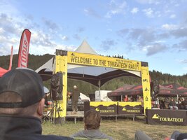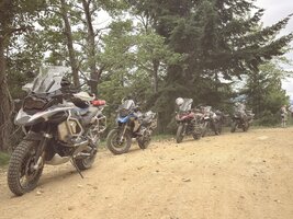

Hey everyone, I just wanted to share my little summer adventure I had going up to Touratech Rally West. Previously I was using this post to see if anyone else from the forum here was going. For those that don't know, Touratech is a major manufacturer of expensive bits and bobs for adventure bikes, and to encourage everyone to get out and ride, they host two rally's. Rally West, in the Pacific Northwest, and Dirt Days in the northeastern part of the US. It's a typical motorcycle rally, so there's a vendor marketplace, demo rides, cold showers, power point presentations and training opportunities, and food trucks.
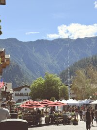
The Rally takes place in the small town of Plain, Washington, about 30minutes outside of Leavenworth. If anyone's ever been, then you'll know that it's a beautiful town, done up in the German Fach Werk style of construction. If you're interested, I can attest that this area is a dead ringer for the Austrian Alps. I think if I hadn't have had the opportunities to travel for work and have been able to explore that part of the world, it would have never occurred to me that visually, the town of Leavenworth looks and feels the same as being in Austria in the Alps. The rally typically runs Thursday the 25th through Sunday the 28th, in that 4th week of June.
For personal reasons I didn't leave the bay until that Wednesday, making for some longer mileage days.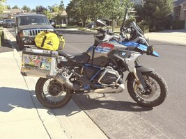
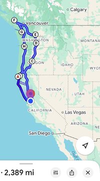
Day 1 from the Bay to Crescent City. 411 miles - If anyone's forgotten, sometimes simple is the easiest and delivers the best balance of getting there vs. getting lost. 101 north of Geyserville becomes better and better. It's truly a remarkable road, turning into a well paved set of twists and turns the further you go. It allowed me to keep a very nice pace, for which a fully laden GS enjoys. I took some time to make a small side trip and ride through the tree in Chandler. A giant that has stood the test of time.
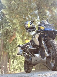
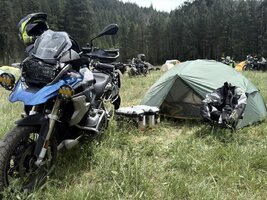
There's a Safeway in Crescent City which was probably a good idea but I went past without realizing it. Fortunately I had already eaten and was just looking for basics, water, and snacks for camp. I found a gas station with a general store in Gasquet, stocked up, and then made camp at Patrick Creek along the 199. There's no cell service there, but I had brought my Starlink Mini. Powered from my Anker 26k battery pack, this was super handy. Checked in with home and settled into camp for the night.
Day2 - Patrick Creek to Biggs Junction, 403 Miles
Riding up the 199 is pretty fun. In fact, I believe that California has the best kind of sport touring riding, and it's easy to forget that California is blessed compared to what the rest of the country looks like. Occasionally I have to travel to HQ for work, so I find myself in places like Jupiter, Florida, absolutely gobsmacked at how flat and straight everything is. Not to mention humid.

I woke up the next morning and hit the road, headed for Grant's Pass. A quick fuel stop then it was onto highway 5 to Medford to pickup highway 62 and start heading north again. This brought me out into Umpqua National Forest and around Crater Lake National park. Travelling through this part of Oregon is special. The forests are quiet and cool, with the trees towering over you. In a year prior I had taken a portion of the TAT which connects Crescent lake junction and Deschutes national forest through to Diamond lake. That was a fun, easy dirt road, which climbed and climbed the north side of Diamond Peak. To the point of snow, in late June! On that trip, I had run into a Father and Son, in the wilderness. The son was on a KTM 1290 and the Father on a DR650. They had started their journey weeks prior in Virginia and had been traveling the TAT. They were nearly there, to the Pacific. As I continued to crest the pass on Diamond peak, I don't recall seeing their tracks, but justified to myself that they had just passed through, so it's fine, I can do it! On the south facing slope, I found that the sun had melted all the snow, but created a water feature approximately 25 yards long, which the GS conquered with ease.
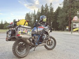
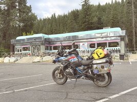
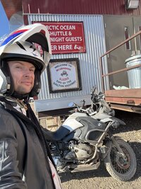
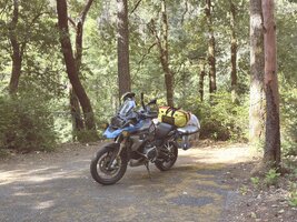
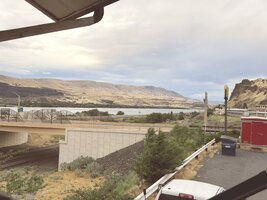
This trip, there would be none of that, It was only Day 2 and I had a full day of riding to get there. Coming around Crater Lake, I joined the 97 northbound in Beaver Marsh. It is inevitable, to get the miles, one must do the slab. I only took two pictures this day, both on my iPhone. When I departed Patrick Creek and when I arrived in Biggs Junction.
This year I stayed on highway 97. I had thought that it was a possibility that I would extend and go for the 600 mile day, so diverting onto the 197 and travelling through Maupin wasn't necessarily the most direct route. I had done the Maupin route twice before, and have become quite fond of the Imperial River Company, in Maupin, Oregon. Along the Deschutes river, the Imperial River company hosts a hotel, rafting company, a restaurant, and is a very nice place to put up for the night, if you are lucky and can get a room. Having no plans, the alternative was to camp at the city park along the BLM Access road by the river. Maupin is a small town, set on a hillside overlooking the river, and came into existence supporting the river and rail based trade route between Bend and Washington. Nothing better than jumping into the frigid waters from the dock at the Imperial River Company and being swept downstream, to the city park boat and water access where you can get out. For strong swimmers only, mind you.
The journey north, wound out along what I would call high plains, a fairly straight and uninteresting road across a desolate piece of country, with some high crosswinds challenging the GS. Storm clouds dotted the afternoon sky, easily seen for miles in the wide open country. A quick check of the weather radar showed rain squalls moving across the north west. As I got closer, I realized the timing of it all wouldn't be prudent. I would arrive at the rally grounds at around 9:30Pm, with gates that close at 10pm every night. Not only that, it would be raining, and I would have to setup camp in the dark and in the rain. Being the reasonable person, I decided to stay overnight in Biggs Junction.
Biggs Junction is a truck stop along highway 97, with a Pilot and a TA Express travel center. Overlooking the Columbia River, it is located upstream from the Dalles Dam, and downstream from the John Day dam, just west of Celilo. The Columbia River has it's own share of history, but more impressively, this is the start of the Pacific DC Intertie. The PDCI is a 3.2gigawatt High Voltage DC transmission line with converter stations in Celilo, Oregon, and Sylmar, California. A project by Los Angeles Department of Water and Power (LADWP), the PDCI brings power from the hydro on the Columbia River (from Bonneville Power Administration BPA) to Los Angeles, via a 846 mile overhead transmission line. The project was authorized by JFK in 1961 and was completed in 1970, using mercury arc valves. It supplies around 40% of the power to the Los Angeles basin.
After considering my options, I decided a cheap motel room at the Biggs Motel by the Pilot truck stop was probably the best option. The room itself wasn't bad, the shower was adequate, and by all means I have seen worse budget rate hotel rooms in Mexico. The freight train only came by a couple times but by midnight I was out cold.
The Rally takes place in the small town of Plain, Washington, about 30minutes outside of Leavenworth. If anyone's ever been, then you'll know that it's a beautiful town, done up in the German Fach Werk style of construction. If you're interested, I can attest that this area is a dead ringer for the Austrian Alps. I think if I hadn't have had the opportunities to travel for work and have been able to explore that part of the world, it would have never occurred to me that visually, the town of Leavenworth looks and feels the same as being in Austria in the Alps. The rally typically runs Thursday the 25th through Sunday the 28th, in that 4th week of June.
For personal reasons I didn't leave the bay until that Wednesday, making for some longer mileage days.
Day 1 from the Bay to Crescent City. 411 miles - If anyone's forgotten, sometimes simple is the easiest and delivers the best balance of getting there vs. getting lost. 101 north of Geyserville becomes better and better. It's truly a remarkable road, turning into a well paved set of twists and turns the further you go. It allowed me to keep a very nice pace, for which a fully laden GS enjoys. I took some time to make a small side trip and ride through the tree in Chandler. A giant that has stood the test of time.
There's a Safeway in Crescent City which was probably a good idea but I went past without realizing it. Fortunately I had already eaten and was just looking for basics, water, and snacks for camp. I found a gas station with a general store in Gasquet, stocked up, and then made camp at Patrick Creek along the 199. There's no cell service there, but I had brought my Starlink Mini. Powered from my Anker 26k battery pack, this was super handy. Checked in with home and settled into camp for the night.
Day2 - Patrick Creek to Biggs Junction, 403 Miles
Riding up the 199 is pretty fun. In fact, I believe that California has the best kind of sport touring riding, and it's easy to forget that California is blessed compared to what the rest of the country looks like. Occasionally I have to travel to HQ for work, so I find myself in places like Jupiter, Florida, absolutely gobsmacked at how flat and straight everything is. Not to mention humid.
I woke up the next morning and hit the road, headed for Grant's Pass. A quick fuel stop then it was onto highway 5 to Medford to pickup highway 62 and start heading north again. This brought me out into Umpqua National Forest and around Crater Lake National park. Travelling through this part of Oregon is special. The forests are quiet and cool, with the trees towering over you. In a year prior I had taken a portion of the TAT which connects Crescent lake junction and Deschutes national forest through to Diamond lake. That was a fun, easy dirt road, which climbed and climbed the north side of Diamond Peak. To the point of snow, in late June! On that trip, I had run into a Father and Son, in the wilderness. The son was on a KTM 1290 and the Father on a DR650. They had started their journey weeks prior in Virginia and had been traveling the TAT. They were nearly there, to the Pacific. As I continued to crest the pass on Diamond peak, I don't recall seeing their tracks, but justified to myself that they had just passed through, so it's fine, I can do it! On the south facing slope, I found that the sun had melted all the snow, but created a water feature approximately 25 yards long, which the GS conquered with ease.
This trip, there would be none of that, It was only Day 2 and I had a full day of riding to get there. Coming around Crater Lake, I joined the 97 northbound in Beaver Marsh. It is inevitable, to get the miles, one must do the slab. I only took two pictures this day, both on my iPhone. When I departed Patrick Creek and when I arrived in Biggs Junction.
This year I stayed on highway 97. I had thought that it was a possibility that I would extend and go for the 600 mile day, so diverting onto the 197 and travelling through Maupin wasn't necessarily the most direct route. I had done the Maupin route twice before, and have become quite fond of the Imperial River Company, in Maupin, Oregon. Along the Deschutes river, the Imperial River company hosts a hotel, rafting company, a restaurant, and is a very nice place to put up for the night, if you are lucky and can get a room. Having no plans, the alternative was to camp at the city park along the BLM Access road by the river. Maupin is a small town, set on a hillside overlooking the river, and came into existence supporting the river and rail based trade route between Bend and Washington. Nothing better than jumping into the frigid waters from the dock at the Imperial River Company and being swept downstream, to the city park boat and water access where you can get out. For strong swimmers only, mind you.
The journey north, wound out along what I would call high plains, a fairly straight and uninteresting road across a desolate piece of country, with some high crosswinds challenging the GS. Storm clouds dotted the afternoon sky, easily seen for miles in the wide open country. A quick check of the weather radar showed rain squalls moving across the north west. As I got closer, I realized the timing of it all wouldn't be prudent. I would arrive at the rally grounds at around 9:30Pm, with gates that close at 10pm every night. Not only that, it would be raining, and I would have to setup camp in the dark and in the rain. Being the reasonable person, I decided to stay overnight in Biggs Junction.
Biggs Junction is a truck stop along highway 97, with a Pilot and a TA Express travel center. Overlooking the Columbia River, it is located upstream from the Dalles Dam, and downstream from the John Day dam, just west of Celilo. The Columbia River has it's own share of history, but more impressively, this is the start of the Pacific DC Intertie. The PDCI is a 3.2gigawatt High Voltage DC transmission line with converter stations in Celilo, Oregon, and Sylmar, California. A project by Los Angeles Department of Water and Power (LADWP), the PDCI brings power from the hydro on the Columbia River (from Bonneville Power Administration BPA) to Los Angeles, via a 846 mile overhead transmission line. The project was authorized by JFK in 1961 and was completed in 1970, using mercury arc valves. It supplies around 40% of the power to the Los Angeles basin.
After considering my options, I decided a cheap motel room at the Biggs Motel by the Pilot truck stop was probably the best option. The room itself wasn't bad, the shower was adequate, and by all means I have seen worse budget rate hotel rooms in Mexico. The freight train only came by a couple times but by midnight I was out cold.
Last edited: