• There has been a recent cluster of spammers accessing BARFer accounts and posting spam. To safeguard your account, please consider changing your password. It would be even better to take the additional step of enabling 2 Factor Authentication (2FA) on your BARF account. Read more here.

Yosemite to Death Valley Adventure Loop

Day 7 continued
main.php


Continuing on I headed down Badwater Road. There were a lot of cruisers going in to the park probably from the motorcycle tour. The ride was somewhat uneventful out of the park. You realize there is so much road to cover. There is a road called West Side Road, that goes from around Artist's Drive to almost the Ashford Mill ruins. Very long high clearance road that goes to these 4wheel drive roads goes into canyons. Did have time to play with that though. The only other spot I stopped at in the park was Ashford Mill Ruins. Its a mill at the sourthern part of the park. Took a break and snapped some pictures. This is probably the 3rd mill I've seen.
main.php
main.php
main.php

main.php
main.php
main.php

main.php
main.php


I made it out of the park and headed towards Shoshone. I got gas there and it was even more expensive than Furnace Creek. Then I check out their little museum, pretty nice little museum. Has some old fossils.

After Shoshone I stopped by Tecopa. I decided to skip camping at Tecopa because I was off my timeline. The main reason I wanted to stay there was because I could use the hotsprings there which is what Tecopa is known for. Later I got my chance to go to a hotspring by a chance encounter but that's later. Not much to see in Tecopa. There are a buncha those choco mountains and I just got off the highway at some point and start riding in a choco canyon. The mud mountains are actually really soft I found out.
main.php
main.php


The next section is probably the worst stretch of road I have ridden. This was the 127 to Baker. On the Butler maps it has the buffalo skull on it, which means its a Lost Highway. Haha and it is. Your riding and riding and it just desert everywhere and roads as far as the eye can see. On the way I did stop by the Dumont Dunes though. Just to take pictures of the dunes, no dune riding for me, save that for Pismo.
main.php
main.php

main.php

IMG_20141002_141033.jpg


I make it to Baker finally and I refuel. There are cruisers everywhere apparently there was some biker festival in vegas but I was heading the other direction. First thing I'm lookin for is an autoparts store or some kind of department store. NOTHING! Reason I needed to go to one was to get an airpump because mine broke. Baker has some interesting places to see. I stopped by the Tallest Thermometer in the world. Apparently the hottest day in the world took place in Baker way back when. They even had some pennies I could smash. Then there is this wierd Alien Jerky store that I thought was cool. They had some Alien cars and flying saucer. Couldn't miss a chance to take a bike picture with em haha. Then I head to Del Taco to get some food.
20141002_152221.jpg
main.php

PhotoGrid_1412291239720.jpg
 
Time to head to the Mojave! Not far from Baker is Kelbaker Road. This road goes straight through the Mojave and spits you out at HWY 40. Its about 1700ish so its starting to get dark. Riding through Kelbaker Road near Baker there are a lot of dips and sometimes sand washes, but nothing too bad. The Mojave Preserve is how I would describe as a giant scenic desert garden. I found out that tree you see on the park logo is called a Joshua Tree. I found a good one and took a bike picture of it. As you move through the park the vegetation changes a lot. From desert bushes, joshua trees, sand dunes, and more. Unfortuanately I was just passing through.
main.php
main.php

main.php
main.php


I stop by Kelso Depot but the vistor's center is closed. Damn no souvenirs. I grab a couple park maps and use the restroom and hit the road. Its getting dark and I wanna get to Kelso Dunes and get that dusk shot of the dunes. There is a about a 2 miles dirt road going to Kelso Dunes. You follow it until it say 4 wheel drive recommended and you start to get into some really soft sand. That's when I stopped. Kelso Dunes is also known as the Devil's Playground.
main.php
main.php

main.php
main.php

main.php
main.php
[/IMG]

The sun goes down and I head on out of Mojave Preserve. Its gettin a little cold so I put my jacket on. I eventually get to HWY40 and the speed limit is like 70 so I'm blastin down it. I stop by Ludlow to rest and continue on to Barstow.
main.php


At Barstow I head to Walmart and get some supplies, namely a new airpump. I windup getting one of those Slime Tire Top off, small and it has a pressure gauge, I have a couple at home for other bikes. I try to find a place to camp for the night but I don't see anywhere interesting. So I decide to press on to Edwards Air Force Base. I head west on 58 and this highway is horrible to travel at night. Its 2 lanes sometimes with no barrier. It pretty late around 2300 or so when I get to Edwards AFB gate. Flash my military ID and I'm in. I really have no idea where to go but I'm looking for the Famcamp. I plug it into my google maps and it get's me pretty close. Its totally dark so I really have no idea where I'm going, but this base is HUGE. I find the Famcamp and setup camp. Its actually pretty nice. I've never camped at a military campground before but its only 5 bux for tent camping. There's showers, a day room, and a laundry room. Finally I can get a shower! Whew that was a very long and eventful day, next day Flight Test Museum!
main.php
 
Day 8- Edwards AFB, Flight Test Museum, Black Bird Park
main.php
main.php

The Famcamp
main.php

I wake up kinda late, there's not a whole lotta riding to do today. I allocated this whole day to going to the museum. The main reason I stuck to the time table was so I could get to the Flight Test Museum before the weekend because it was closed on the weekend.

I'm a big fan of aviation and military aviation in particular. I always enjoy going to an air museum and this one is special. Last time I went to the Museum of Flight in Seattle. Edwards Air Force Base is a base with A LOT of history in the aviation community. Lots of history was made here. Edwards AFB is best known for test flying. They fly a lot of experimental and prototype aircraft here. It seems like everyday there is an airshow here, you see F16s and F22s taking off and flying. NASA's Dryden Flight Research Center or now known as Neil Armstrong Flight Research Center is on this base as well. Now I'm fortunate to be able to even enter the base because I'm in the Army National Guard, not just anyone can visit this base.
Here's how the day starts out. I get a good nights sleep. I actually got lucky because I came in after midnight I really only have to pay for one day to stay one more night. I leave my camping gear and head to the BX because I need some supplies. Before that I ride around the neighborhoods a little, because I didn't see any of it the night before. I go shopping and the big item I'm looking for is some kind of polishing cream. My camera lens on my LG G3 is all scratched up from Yosemite and I'm hoping I can fix it with some polish. I manage to find some mother's aluminum polish. After eating some brunch the security forces are holding a K9 demo. Pretty cool, next I head back to camp and attempt to fix my camera. Guess what!? It worx, so from here on out no more foggy pictures. Great because I'm about to snap up a storm!
PhotoGrid_1413359589108.jpg

Security Forces Demo
http://instagram.com/p/ts51FIQOpE/

F22s taking off
http://instagram.com/p/ttJMLHQOji/

I head to the Flight Test Museum. I didn't have to ride far because its like 2 blocks from the Famcamp. I even ride through a couple unpaved roads to get there. Hard to miss because there is this giant B-52 bomber in the airpark. I head in and my mind gets blown! I walk in and I see rocket engine and giant superchargers. Then I look up and there it is a replica of the Bell X1, the plane Chuck Yeager broke the speed barrier with. I turn around the corner and the YF-22 greets me. The YF-22 is the prototype F-22 that went up against the YF-23 and won. So cool! First time I've seen a F-22 upclose too, what a beauty. There are tons of little model planes everywhere, guns, bombs, milssiles, too cool! There is a seat from a F-35. Out in the parking lot is a little Airpark, well a big one. There's a B-52 bomber, a Blackbird, YF-A10 (prototype A10), YF4, a F16XL (F16 with a Delta Wing), and more sooo rad!

YF22 at Edwards Flight Test Museum. Notice there is a model of the competing model YF-23
http://instagram.com/p/ttKpoNwOmA/

20141003_130756_Pano.jpg

20141003_130518_Pano.jpg


IMG_20141004_073505.jpg
PhotoGrid_1413354788105.jpg


So I'm done playing at the museum and head back to the camp and I'm reading the base brochure I got from the museum and it says in Lancaster (more like Palmdale) there is another airpark called "Blackbird Park." I've heard of this, they have 2 SR71 Blackbirds and a U-2 parked there. It going to close in about 45 minutes! So I plug it into google maps and ride there. Its a pretty long ride but I made it like 15 minutes before they close. The guard tells me he's going to close up soon so I literally run all over the airpark and just start taking pictures like crazy. Then I'm wondering where's the Blackbirds? I asked the security dude and he said they're on the other side. Little did I know there are actually two airparks right next to each other. They were closed already but he said if I wanted pictures of the birds I can just take it from the gate. AWESOME I have seen a total of 3 Blackbirds before this. But I've never seen 2 Blackbirds in the same place and a MD21 Drone is there too. You can see the U2 also but it was hard to get a good pic of it.
main.php

IMG_20141003_162912.jpg
PhotoGrid_1412379153421.jpg

main.php
main.php

main.php

This 747 is was modified to carry the Space Shuttle.
main.php
 
Last edited:
Before I leave Palmdale I notice there are some big name aviation facilities here. One being Lockheed Martin Skunkworks and Embry Riddle Aviation University.

I head back to the base and there's still some time before dinner chow. I decide to ride around the base and take pictures of cool planes and stuff. First I stopped before the gate and took a picture of the airplanes on display near the gate.

There is so many things to take pictures of. They don't seem so strict about photography on the base like an Army Post is, just flight line photos I guess. Anyway I ride around and find a bunch of cool aircraft. I even find F-22s and a tucked away near the JSF building is the X-35! Yep the prototype F-35 STOVL. I remember its the one from Battle of the X-planes! I didn't take pictures of any of them though because they were in the no photography area. But it was so cool to see these aircraft.
PhotoGrid_1412433754574.jpg


I even found Chuck Yeager just chillin at a street corner, well a statue of him anyway. There was strangely no place to park so I just parked near the curb and had to get a photo with him.
PhotoGrid_1412433950092.jpg


The DFAC is going to close soon and I'd like to try this Air Force DFAC out. An Air Force DFAC is a little different from an Army one, at least this one was. You grab all your food prior to paying for it at the register. They total everything up and then you pay for it, kind of like at Ikea. An Army DFAC is the other way around. Still it was a good deal around $5 and it was pretty good. Not as fancy as I had thought it would be. Glad to see I am taking advantage of my military benefits =)
IMG_20141003_184133.jpg


I head back to the Famcamp and that night I meet Kevin walking to the bathroom. He was asking about my bike and was wondering where I've been. There are a lot of people that do this during my trip but Kevin a big rider. He has a Z1000 and 2 Honda Grohms . We were chatting away about dual sports and how there's nothing to really do out here but just go riding haha. I believe it too because the lady working at the museum said she's a trail rider. But he told me about a someplace cool to visit on the base. It was an aircraft boneyard that had 2 B52s and a B58 Snoopy bomber. He said you go down this road and when it turns dirt you keep on going down a dirt road and bam there they are. He said it totally legal to go and visit them. So I'm like man... its kinda outta my way but sounds like a fun adventure. So I'm thinking I'll go do.
 
Last edited:
Day 9- Neil Armstrong Flight Research Center, Bomber Boneyard Adventure, Quail Run Ostrich Ranch, and Hungry Valley SVRA
main.php
main.php


Its the next day and I pack up camp and leave the Famcamp. I've decide I am going to attempt to find the boneyard. So I don't know what happened but I got the Kevin's instructions all messed up and I went the opposite way. For some reason I thought it was on the northern part of the base. So I ride up the road and see a dirt road on the left but it's leading me to this rail roads tracks that doesn't look like where I'm suppose to be. So I'm a couple miles in and its getting really sandy. This has to be the wrong place so I google the place I'm looking for and after a little bit of googling I find some stuff on it's location and it actually on the southern part of the base not the northern. So I head back but decide to take a road that will take me straight south.

Panoramic of Edwards AFB
20141004_100108_Pano.jpg


I'm riding around and fine some fences that stop me so I take some off road detours and find another way around. Then I see a bunch of aircraft parked and one of them looks like a blackbird. I've somehow unexpectedly wound up at the NASA Neil Armstrong Flight Research Center! There is a nice airpark outside the gate and several X aircraft that were used in aviation experiments are parked here. My favorite one of all is the Grumman X-29. I've read about this plane in encyclopedias when I was a child and learned about it in college. To see it right in front of me was too awesome. The X-29 was a plane that was built to experiment with forwards swept wings, its a really rad plane. There some other cool aircraft too, a starfighter, 2 F-8s, and of course a SR71 Blackbird. I couldn't get that far into the research facility but I was poking around google earth and I found a F15 ACTIVE and a F-16XL, but who knows when that picture was taken.
main.php
main.php

PhotoGrid_1412457019279.jpg

IMG_20141004_140220.jpg


So awesome I found another cool place by chance. After drooling all over the aircraft I head back out due south. So there is another base gate if you just head straight south. So I do that and supposedly before I get to this gate I'm suppose to take a left somewhere. Well I pass it and I'm thinking that's the street but go further just incase there is another one. Nope I'm nearly at the gate so that was the one. So I turn around and go down that road I passed. So from my understanding Kevin told me to ride the slab until it turns into dirt, but it lead me straight to a fence. Now the road started turning to the right about 1/2 mile ago. At that point I did see an aircraft out there. So I turn back and right when the slab starts to change direction I see the dirt road! So I follow it, not a difficult ride but there was loose sand patches. The first one was the worst. I tried to power through it and duck walk through it and managed my way through barely without getting stuck. I didn't air down though so that's not helping. Then there it is the B-58 Snoopy. Found one and took a buncha pictures. I move the bike under the plane for other pictures.
main.php
IMG_20141004_122538.jpg

Then it's time to go to the 2 B-52s! I follow the dirt road and there are 2 more loose sand patches but not as bad as the very first one. I manage to get through and I arrive at the 2 massive bombers. I take another under the wing picture on the one that is still intact. Then I drive through the other ones, yes that's right I drove through its broken fuselage and took picture of the bike there. Haha how awesome is that. Then I proceed to take more picies of the aircraft and dry lake bed. Interesting fact Roger's Dry Lake bed is used to land the Space Shuttle if they can't land it in Florida. So wow what an adventure, nothing like riding through the desert to look at old planes. I was googling earlier and notice that there are more site like this in the desert not too far away. I'm happy with these though. So I head back and out of the base, so long Edwards Air Force Base, its time to start heading for the coast!
main.php
PhotoGrid_1412450869329.jpg

20141004_120735_Pano.jpg

20141004_121633_Pano.jpg

20141004_120830.jpg


There's a DR650 somewhere
20141004_121155.jpg


360 of Roger's Dry Lakebed
http://instagram.com/p/tvfhzowOv1/

B52 Boneyard out in the middle of the desert wat an adventure!
http://instagram.com/p/tvgUONwOhv/
 
Continuing on I bid farewell to Edwards Air Force Base. I leave the South Gate and start following my tracks heading to the coast. I'm a little off track but I manage to make my way through Lancaster. Its a pretty long boring ride till you get to the hills.
main.php
main.php


I'm riding through a canyon and take a break at Lake Elizabeth. It's a sad little lake park, the water has dried up quite a bit.
main.php
main.php


Now here is where I run into a continuing misfortune that reoccurs the rest of the ride. I am suppose to head up this forest road that goes up into the mountains. It was a a recommended dirt road in the Butler Maps. So I go and it says the road is closed, I almost miss it if I didn't program it in my GPS. Well about 2 miles up the forest road there is a gate that is locked. So its a no go I head back down. Bummer closed because of forest fires. So I head down the slab instead.
main.php
main.php


Well I'm riding down the road and I spot a sign that says there is an Ostrich Ranch up ahead and they do tours. I'm like well why not!? I don't think I've seen a real live ostrich before and I'm always taking pictures with goofy animals like llamas. I stop by and they convince me to take the ostrich tours which is a whooping $5. I learn a lot about ostriches, they are actually very interesting birds and they raise them for various reasons. Did you know in a match between a lion vs ostrich the ostrich can defeat the lion 50% of the time!? I get to take pictures of them and feed them. I buy a few souvenirs and get back on the road.
main.php

PhotoGrid_1412462892262.jpg


So back on the road. According to my tracks I can find another forest road going through an old historical highway called Old Ridge Road. I take it for some time it's no longer maintained. Its got asphalt, gravel, potholes, and rocks everywhere perfect for a dual sport. I take it for a while and there are some amazing views. Well I get to this look out of some sorts and try riding around the look out and almost eat it going down the other way because it was steep and slippery going down. But anyway I continue on and little ways down the road ANOTHER locked gate, forest road is closed =( So I have to head all the way back and pretty much just head to I5 from there.
main.php
main.php

IMG_20141004_163133.jpg

20141004_163314.jpg

IMG_20141004_165028.jpg


main.php
main.php


So next stop is Hungry Valley SVRA. Always pass by it on the I5 and wanted to go check it out. I ride down the I5 for a bit and turn in to Hungry Valley. Now supposedly I'm suppose to take some forest roads here that will lead me all the way to Santa Barbara. The ranger at the booth says he doesn't recommend it because there its a jeep trail and wouldn't be good for a motorcycle. He says to the 5 to 126 and ride to the coast from there. So that's what I decide to do but he says I can just go into the park for free right now because he's already closed up shop so he can't take my money. He told me I should pay the next day if I'm camping. So its getting late so I decide to camp here. I get a park map from him and try to take this Pipeline trail to the campground. OMG its MORE desert riding. The sand is deep and so loose here. I air down and am thinking this probably won't be very fun on a motorcycle. I would have much rather have a quad here. I manage to power my way through the sand not very gracefully I might add and make it to the campground. I find a spot and setup camp and shed as much weight from the bike as I can so I can hit the trails. Well to my surprise the bike now has LESS traction because I got rid of all the weight in the back. It was so hard to get out of the camp for some reason, the sand was really deep. I go down the pipeline trail for a while and I decide to take a trail that goes along the mountain then goes back down and I just need to take the slab back to camp. It gets dark and I have a hard time finding my way. So now I'm riding in the desert at night again haha. I was having fun though, I manage to find the trails I was looking for almost gave up. The trails where I went up in the mountains were not so bad, not as loose. I notice the higher you go the less loose it gets. I manage to find my way back to camp. Once again I'm thankful for offroad lights. Now like an hour or two later this huge mexican family comes and just takes over the camp ground. They must have had like 8 cars/trucks with them. They setup shop and blasting their music and doing donuts in their quads in the campground kicking up dust. They were so annoying that the people right next to me just packed up and left with their giant toy hauler. Jeez couldn't they go ride away from the camp at least, there's so many places to ride. Anyway they were very inconsiderate but I'm lucky I am a heavy sleeper. I decide I will NOT pay the camping fee in the morning because I'm having a horrible stay thanks to these people.
main.php


Look at how deep sand is on the Pipeline trail is
20141004_174210.jpg

20141004_174822.jpg
 
Last edited:
Love the airplane pics ... guess you need to be a vet to camp at Edwards AFB?

Too bad about inconsiderate people at Hungry Valley ... I camp a bunch at Hollister Hills, but the noise and crowds don't really bother me there since it's an OHV park and that behavior is to be expected ... Otherwise I simply avoid established campgrounds ... :ride

Looking forward to seeing how you make your way back to the Bay Area! :thumbup
 
Yeah they were making a racket until midnight, I already had my tent setup so I didn't feel like moving to another camp. They came after the gate closed too so they could party I bet, oh well they were having a good time with family and friends I could definitely tell.

Yeah you need a military ID, Privledge card when you retire, or be a disabled veteran. If you know someone in the military they can probably get you on also. Some army posts I know will let you in if you have a state issued ID and you just show your registration and insurance and they might let you in. Can't really go anywhere or shop anywhere without a military ID though.

I have heard they have open base days though, probably when they have airshows. I highly suggest checking it out if you get the chance. Also the flight museum is trying to move somewhere just outside the base so the public can come see the museum anytime, that won't be for some time though.
 
Day 10 - Sloan Canyon Road, 126 to 101, Gibraltar Road, San Marcos Road, Gaviota Hot Springs, Santa Rosa Road, Vandenberg AFB, Ocean Dunes
main.php
main.php


I wake up early, pack up, and head back to I5. Couple vehicles already heading into the park and there's no1 at the ranger station so I couldn't pay if I wanted to. When I get to the slab I air up and hit the 5. First order of business is gas, I'm about 150 miles on the tank so filling up takes priority. I stop in a town called Castaic and gas up. I see a lady with a nice colorful parrot at the gas station. It turns out she's got a minivan full of parrots. I grab some breakfast at Jack n the Box and look at google maps. I find a shortcut that would take me to 126 that's more interesting than taking 5. So I head down it.
main.php

IMG_20141005_063848.jpg

IMG_20141005_083513.jpg


This road is called Sloan Canyon. I start riding it and then realize it's like a long dirt residential driveway. I thought it was private but there are no gates so I just go ahead. It's a nice easy dirt road. I get to a section where it says your not suppose to enter because it's private property and there is a gate but its not locked. So I do try to bypass it and then realize I have to go back to 5 so I said oh well I'll just roll through real slow so I don't bother anyone. There's are horses and stuff but they don't seem to mind. I make it to some slab and eventually make it to 126, that was a fun detour.
main.php
main.php

main.php
main.php


I make it to 126 and this is a really nice freeway. Its not boring like 5. Anyway I quickly realize there are tons of nurseries and farms here. This area must be good for growing plants and trees. I can't say I have ever seen so many giant palm trees for sale in one place. Its a nice scenic ride. Eventually I make it to Ventura, the 101, and the COAST! I've done it from forest to desert to coast! I get some lunch at a McDonald's and decide I must get a beach picture since I've made it to the coast. I find a nearby beach and manage to get a good one.
main.php

PhotoGrid_1412531679489.jpg


So I'm getting close to where my tracks are on my GPS. I manage to get back on track and head up Gibralter Road. OMG this is one of the most spectacular twisties I have ever ridden! One thing you notice as you are going up is there is a fire hazard warning sign in the neighborhood. Then you notice it gets much warmer o_O
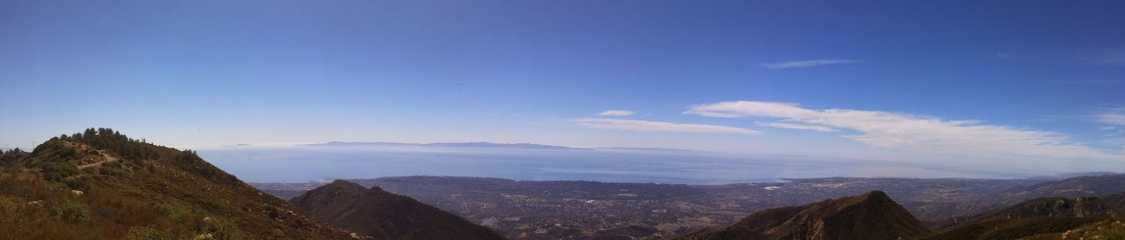
'. But that doesn't stop me I'm lovin it. Spectacular views around every corner and spectacular corners! You can see all of Santa Barbara on one side and Los Padres National Forest. I heard there are dirt roads here also but I'm pretty sure they were closed because of fires. Thanks Butler Maps for this one, it definitely was worth going here. I even get a free airshow at the top there are paragliders flying around. If your are in the Santa Barbara area definitely check this road out you won't be disapointed! When you start going down it, it gets even better, more twistier more fun!
main.php
main.php

main.php
main.php

IMG_20141005_113920.jpg

PhotoGrid_1412535005565.jpg

0m0ExEZ70aGrjlZHpphfT_7mkIi5YLTxf4PIa0fZKrBf=w1579-h339-no

20141005_122452_Pano.jpg


Movie of Paragliders
http://instagram.com/p/tyCb8HwOqV/

Panoramic at top of Gibraltar Road
http://instagram.com/p/tyD7gYwOt6/

So I finally make it down Gibraltar Road. Its a long road that takes you to the other side of Santa Barbara. I follow my tracks to another very nice road San Marcos Road. I think this used to be an old highway or something. Anyway it fun too but you gotta go much slower because its sorta in a residential area. My favorite part are these 2 crazy tight hairpin turns. It was so fun I had a snap a picture of it and ride up it and back down it again.
main.php
 
IMG_20141005_124959.jpg


Next stop and an unexpected stop Gaviota Hot Springs!
 
Props to you! This is an excellent adventure you've taken us on!
 
Thanks for reading Maddevil, it was definitely a ride I will never forget and hopefully this'll help people plan their rides in the future.

Continuing on. I head down 101 for quite some time. I'm still contemplating where to go but I'm pretty much going to follow my tracks. I'm near the coast again so it's nice a cool again. Then I start heading inland more and come upon the 101 to 1 junction. I realize oh crap I missed the exit I was suppose to take to go down this nice road the Butler Maps has. So I exit and I'm getting pretty tired and it getting pretty warm now. So I exit and take a break to get my bearings and I head down this road and there is a small dirt lot next to the freeway. I realize this is a some kind of trailhead and people coming here to hike.

I look it up and there is something called Gaviota Hot Spring! I google it and it says the hike is less than a mile! I'm like awesome, its hot and I feel like I need a little bath. I run into a guy in the parking lot and we chat for a while about my journey. So I get ready to hike up the hill and it really is a steep hill. But its less than a mile and after I cool off at the spring its an easy downhill hike back, I wish I wore shorts though.

I'm hiking and its pretty steep I got my backpack and towel with me also so I'm sweatin up a storm. A dude I was hiking with tells me where the spring is but I guess I get confused and overshoot it. You can definitely hear the spring back there. There was a part where there was some kind of plastic piping contruction, that was actually the turn and it kind turn into a really tight single tracky trail. I go up it for a little bit and SUCCESS I finally make it to a hot spring.

Now I don't feel so bad for missing Tecopa and this is a totally natural hot spring, not some kinda pool. There is a couple there soaking in it already. I was talking to them and they tell me that this area hasn't had any rain for like 3 years already, so I guess they've got it worse than us. I tell them about my adventures and the dude tells me he has a XR650. Nobody is naked so I don't feel like taking all my clothes off so I just soak in it enough so I don't get my briefs wet. My mesh gear will dry fast anyway, I settle for a quick bath. Its pretty nice but its kinda mucky and smells like sulfur. Also the spring is kinda rocky and I cut my toe a little, luckily it didn't get infected. Another dude comes running in, apparently he was running up the trail, he says the hike it pretty tough here. Everyone leaves and I snap a buncha pictures, dry my feet, and start heading down the trail. The hike back was pretty ez just as I'd expected steep downhill. My Tshirt and pants are soaked, so now I'm nice and cool and it'll feel great when I get on the road. What an unexpected event! The parking was $2 but it was worth it. Time to head on to Santa Rosa Road.
main.php
main.php

main.php
6Kx3ZG9a6ST_j86Tuf0P2T1d0qSufhY-UuKbcMKwqLEO=w147-h196-p-no

PhotoGrid_1412548210080.jpg
20141005_144237.jpg

20141005_143455.jpg

20141005_153627.jpg


Hot spring movie
http://instagram.com/p/tyYjFewOqW/
 
Last edited:
Next section is Santa Rosa Road to Lompoc. Santa Rosa road is a road a fairly easy twisty road with views of ranches and vineyards. I would have to say it like riding in Salinas with more vineyards. Kinda like if you combines Livermore with Salinas. Its a fairly easy road that is somewhat goatie in certain sections. Very nice scenic ride though.
main.php
main.php

PhotoGrid_1412550634046.jpg


By this time I'm starving. I'm riding through Lompoc and they have so many Fish n Chip restaurants. I gas up and I decide to hit one up. I go to this fancy british restaurant Alfie's Fish&Chips. If its one thing I know about the Brits is that they love their fish n chips. I didn't think 2 pieces would fill me up but it did. Yummy time to get back on the road. Next stop Vandenberg AFB.
PhotoGrid_1412553296451.jpg


I always get close to Vandenberg Air Force Base but I never get a chance to do go there. Like most Air Force bases it's nice and clean. I really don't have any idea where to go either. I'm just riding around. I find the BX and its a decent sized one but they don't have souvenir coins sadly. Vandenberg is famous for doing rocket launches and other space stuff. They didn't have a museum that I could find and its a Sunday so most of the base is shut down. When I talked to Kevin at Edwards AFB he told me that Vandenberg was a good place to go riding. There are lots of foresty areas but I keep seeing signs saying the area is off limits, so I don't go in plus its getting late I gotta get to Pismo soon. Wish I had more time to explore, but I have to say the base is pretty boring. It kinda reminds me of a college campus. I do however find something interesting I was not expecting to see at an Air Force base. A Korean War Memorial for the 40th Infantry Division. I am wearing the 40TH ID patch on my uniform, my unit belongs to them. So what a strange coincedence on an Air Force Base no less. They had a tank to display also.
PhotoGrid_1412559351403.jpg

Look familiar, that's me rockin the 40th ID patch on my quad. Don't ask why I'm wearing my uniform on my quad at the beach.
5nvDFpi0RGDnDQ3Cnfn4LHhB-bqNeHwtvhjdHrjPMoI=w155-h207-p-no

vFW7pij56j27QwINwo8Q9cOgSgmsUIyqEs4PRO0v1Pgv=w407-h229-p-no
UzD70XZVyhkIh6auHJs0bK6dYdsZa5g8fw3jl9X-TG1m=w408-h229-p-no
SenhYnIl1jTa4qOYfJDwMyZ0DkRhjCQgS3NVG_XQyG8N=w371-h209-p-no
3sH4Zd5BnPKDlovDdZSqspb9Y8gx-du4ALVtQdtcX_Ru=w338-h190-p-no
Lmqejwb2sccszynlywVPvaSO5VjWOlmLJHh8spyst3Qq=w338-h190-p-no
hXMcfPiUOLrXhz-4y_L57Dl26LUNulr9_X4G-oOOwaTL=w338-h190-p-no


Next stop Oceano Dunes
 
So Vandenberg was a little disappointment. I guess when they have rocket launches it must be cool place to be. There are some roads that go around the base near the coast, that must be a fun ride. But the time for riding and scenic enjoyment is over. The sun has set and I need to find a place to setup camp.
main.php
main.php


I head on over to Pismo Beach the closest route possible. I try to go down this road I have on my tracks, I'm not sure where it goes it probably goes to some light house, but I decide there's no point it dark. Its dark and I'm riding down the 2 lane 2way road and its dark. I wound up taking hwy1 there I think but the faster way I think was to take 101. But I took the shorter way. I make it into Pismo and head to the entrance of Ocean Dunes. Now I know why you don't want to come in during high tide because there's less available hard packed sand to ride on.

I air down and here comes my first beach riding experience on a motorcycle. So I head down the beach and it's a couple miles to the OHV area where you can actually camp. Its going ok then it gets a little crazy. The hard pack sand is getting smaller, there's on coming traffic. Your suppose to go 15mph but I'm zooming by at 25mph. I'm hitting these washing and its slapping me around. There's giant seewed I'm running over, there is a smaller creek crossing. Let's just say its much more work getting the OHV area than it is on a quad or automobile. So I'm not sure where I want to setup camp. The lady at the booth said they opened up more of the beach because those snowy plover birds aren't hanging out there anymore. So I'm thinking of going there but I want to stay near a restroom. Luckily when I came here with my van and quad I stayed near one last time and I have the waypoint for it. Now I'm chuggin right along and bam this maybe like 2 foot sand bank (probably someones sand castle) comes outta nowhere and I guess I panic and have to plow through it and I think I stalled the bike and it's down. I manage to pick it up even with all the luggage on it.

These pictures look so misleading, there weren't nearly that many RVs out there and its uber dark right now.
main.php
main.php


I get to my camping area and I try to head into the looser sand area and guess what I get stuck. I'm trying to pull out of it and it's just digging deeper. Fortunately I'm close to where I gotta be, so I decide I'm gonna drop all the luggage and carry it to where I wanna camp. So I'm trying to figure out how I'm gonna get the bike out, it's stuck pretty well. I read up online that you need to just to just give it power then kinda chop the throttle to get it to hook up. You can also jump up and down on the back to get it to hook up. Eventually I get it out. Man riding on the beach is tough on this tank.

My bike stuck in the sand, it stands on its own!
20141005_201122.jpg


I setup camp and some dudes leave a camp fire going and just take off. So I go cook some chili beans there and have a nice dinner. Let me add that the weather is great right now I can actually see the stars, but the next day is not so nice.
main.php


The next day it's super foggy. I'm like what the hell, this seems to happen all the time when I head to the coast. There's is always a ton of fog. There's tons of those little snowy plover birds on the beach.
20141006_094607.jpg


So the next day I get a chance to practice riding in the sand the next morning. Riding in deep loose sand is a different animal. As long as you don't stop your fine haha and like before the faster you go you start floating over the sand. Then if you see a sand bank or deep ruts your don't have to be scared of it, just twist it and plow through that. You can do some pretty cool stuff in deep sand. You kinda just have to let the bike go where it wants, which is kinda scarey because it feels like your not in control your just drifting all over the place, but you can't think like your riding on the pavement. All your steering inputs are very slow so where you think you'd be in trouble on the street your fine on the sand. You can also get the bike to lean and slide a whole lot. The bike also heats up really fast because your moving slowly but the tires are spinning so fast, so your not getting a lotta air to the engine. Watercooled is probably best for sand! Luckily its pretty cool at the beach. Anyway I felt that my beach riding skills got much better but I still dared not venture into the dunes and I didn't have a flag anyway. It's definitely not like a quad, a quad is so much more easier to ride on the sand. However I think it could have been better if I had some good knobbies. By this point of the trip my Shinko700 and T63 were probably 3/4 done already.
main.php
main.php


Anyway by the end of my practice session I was able to get these crazy rooster tails, I could do J turns (surprised how much lean your can get and still keep going, like your riding on glue), donuts, figure 8, ride through the looser stuff, and plow through sand banks and ruts! Fun times.
PhotoGrid_1412624265282.jpg
20141006_103610.jpg

20141006_090557.jpg


I would also like to mention that when I got off the beach and back onto the slab, that my brakes felt like they grabbed much better. I have had this problem with my DR where the brake pads don't bike hard anymore and I gotta squeeze the lever quite a bit more. Well I tried to resurface the rotor with a scotchbrite disc and it might've helped a little to clean the rotor up. Well it turn out riding through the deepsand cleans your rotors! It kinda sands and polished the metal and well it bites much better now, not bad! Also it cleans your rims my rims are nice and shiny now in most places. Good deal!

Shiny, they were caked with dirt before.
wpx4reodzEBlUGtfKZMfiwNcrBgzR8xmISBr6GZps2RX=w338-h190-p-no
DXahHlv1Eikg4UbRShWr4dLFApkYUdk7EXEIM7bKqRWL=w338-h190-p-no


Tires not lookin so hot
gzxzw6eX8Gc3yiY9Wf22XEAt7SrCYlIWw6YAfUoMGrAB=w338-h190-p-no
X7BUpC1XwwLf7LCh23mrx1HEuIWBqNjWBBclUHfzwktC=w338-h190-p-no
 
Continuing on the final day. I manage to make it back to the beach entrance without incident and air up. I notice my chain is loose again so I tighten it a bit. Turns out I've been measuring wrong the whole time so I've been tightening it too much but oh well its still there and I plan to change it when I get home.
main.php
main.php


I hit the slab and head up towards San Luis Obispo. First place of interest is Morro Bay. I've always wanted to check it out but never went. I'm quite disappointed in the weather today. Its very foggy and overcast near the coast so not much to see in Morro Bay.
main.php


I continue ahead. Its just a series of coastal fog and when I move inland or certain parts of the cost it clears up. Luckily when I get to San Simeon and Hearst Castle I manage to hit one of those clear patches. I pull up to Hearst Castle and get some souvenir coins and takes pictures of the visitor center. Didn't have time to go on the tour unfortunately but I've been here when i was younger. I try to take a picture of the castle with the pay to use binos and it comes out ok. So I've visited two castles this trip: Scotty's Castle and Hearst's Castle!
main.php
main.php


PhotoGrid_1412628899214.jpg

main.php
main.php


After I continue heading up on HWY 1 and I come across an Elephant Seal Beach. It was pretty cool all there was a bunch of Seals just taking naps on the beach. They look dead but then you see a couple moving around. Then there is a group of them fighting in the water.
main.php

IMG_20141006_143514.jpg

Seals on the beach movies
http://instagram.com/p/t03xUowOqE/
http://instagram.com/p/t04DDbwOqn/

Now I continue on up HWY1 and it becomes awesome. I've never ridden this part of Pacific Coast Highway before but it is just spectacular views and riding the rest of the way. The elevation changes fairly often so one minute your in the clouds, below, and on top.
main.php
main.php

IMG_20141006_145601.jpg

PhotoGrid_1412633798410.jpg

20141006_152423.jpg

nftozEYe7B0b6vv-VKME50AhVYOkJJFwT2Jj9vISXqi6=w1579-h888-no


Next stop Nacimiento Fergusson Road!
 
Last leg of the journey. So after the epic ride up and down through the Pacific Coast HWY1 I go up Nacimiento-Fergusson Road. I had actually went down this road when I did my Big Sur ride earlier this year. Let me tell you it was fantastic going down and its fantastic going up as well. I didn't get a lot of pictures on it but I did shoot a video that I may upload in the future. If you are in this area I HIGHLY recommend riding this road. It was on the Butler Map for a reason. I get to the dirt roads that lead to Cone Peak and Prewitt Ridge.
main.php
main.php


I took a break about halfway to the intersection to cool off. It was getting very warm right now into the 90s. I stopped at this spot where there was a little creek running down below the road for a break. I took the windscreen off and took off all my inside layers and wet my shirt. Then I'm getting attacked by these swarms of little black flies. Now I remember this from when I was camping on Prewitt Ridge. It was an epic place to camp but the flies were eating me alive even with insect repellent.
main.php

Movie of my rest stop on Nacimiento-Fergusson Road
http://instagram.com/p/t1JHwbwOlO/

Back to where we was the intersection to Prewitt Ridge. I make a decision to not camp there, I was 50/50 on staying another day and camping at Prewitt Ridge and because of these crazy flies I decided not to and was just going to head home instead. I finish the epic ride up Nacimiento Fergusson and it's time for dinner and what better place than the Fort Hunter Ligget DFAC!
main.php

IMG_20141006_170531.jpg


After that fantastic dinner I fill up and head out. The plan is to go through the backside of Los Padres National Forest. According to the Butler Map, there is suppose to be a dirt road that will spit me out in Carmel Valley twisties. This is northwest of Ft Hunter Ligget. Oh I would like to mention that I have been noticing my bike has become harder to get into neutral and harder to shift in general. You'll find out why soon.

First I head out to Mission de San Antonio Padua right next to Ft Hunter Liggett.
main.php
PhotoGrid_1412643234245.jpg


I find out the some of the dirt road that I want to take right next to mission is the property of Ft Hunter Liggett. It was some kind of training ground so I wound up taking the slab. I ride for quite some time through the foresty roads of Del Venturi Road. Then I get to a dirt road called "Indian Road" There are two free campgrounds here. They are pretty nice doesn't look like many people visit here but there are NO fires allowed because of you guessed it high fire danger and forest fires. Then I see a sign that sez that the road is closed up ahead because of the fires. DAMMIT! Once again my plans to ride on these nice dirt roads has been foiled by forest fires. Well I decide I'm going to ride it as much as I can and if I have to turn around I will. The sad thing is if I do turn around I will have no choice and head all the way back to Ft Hunter Liggett and take Jolon Rd to 101 and it will be very boring. =(
main.php


So I riding on the dirt road and wow its not a bad little road. Scenic ride through a canyon. The road is very easy to ride but fun enough where you can slide it around the corners still. I'm enjoying it.
main.php


Well the fun ended when I got to the road closed sign. There was a gate with a downed tree behind it. NOW... I could have just gone around the gate but it did say no motorcycles. If I got caught back there probably would be a hefty fine or could be dangerous so I turn around and take a break at the campground. no point in really going any further up the trail anyway because it would be dark soon and there would be no photo and vid ops.
main.php


main.php
main.php


So I go take a break at the campground I passed by. I take a pee break and decide I need to adjust my clutch because the clutch lever is getting really loose. Well I find out why its so loose. About half the strands of the clutch cable have broken. So a couple strands are holding it now. I'm like WHOA that is bad. I can try to fix it here because I have a spare clutch cable ziptied to the busted cable OR I can try to hobble it home and fix the cable comfortably at home since I'm not too far from San Jose. I opt for the second choice and nurse it home. I head back to Ft Hunter Ligget in the dark trying as much as possible to not use the clutch. It was still useable but didn't wanna chance it. I stop at the the entrance to the Ft Hunter Ligget where the tank is a take a night shot with the tank.
main.php

main.php
main.php

IMG_20141006_193934.jpg


After I head to 101 and high tail it back home. Its nearly all freeway so I didn't use the clutch all that much. It wasn't as bad as I thought it would be. I make it home and it's the end of my adventure. Kinda sad it was cut short but there really wasn't anything else to see since that forest road was blocked.
main.php


ADVENTURE COMPLETE! :thumbup

From altitudes of up to 10,000ft to -200ft and 2400 miles of forests to deserts to the coast my epic adventure comes to a close!

20141006_222406.jpg
20141006_222424.jpg
 
Here's that clutch cable
20141007_104219.jpg

20141007_104244.jpg
 
Also here is a picture of all the souvenir coins I got along the way:
PhotoGrid_1412789430604.jpg

20141007_163238.jpg
 
Last edited:
Back
Top