• There has been a recent cluster of spammers accessing BARFer accounts and posting spam. To safeguard your account, please consider changing your password. It would be even better to take the additional step of enabling 2 Factor Authentication (2FA) on your BARF account. Read more here.

Photos of your bike on location

A fellow Vampire out for a Sunday ride on his Husky 610 Supermoto....

And that's the way it should be! Well done, Vampire :thumbup


MuddySuperMotoChick
 
And that's the way it should be! Well done, Vampire :thumbup


MuddySuperMotoChick

Funny you should mention it as your name came up during conversation regarding getting real dirt wheels on a non-TE 610.

The picture was taken on High Mountain road which runs between Arroyo Grande and Pozo. The picture does not accurately portray the grade which runs between 13-19% through that section.
 
And that's the way it should be! Well done, Vampire :thumbup

MuddySuperMotoChick

Yeah, I own that bike because of you! I need to know what your best dirt solution for that bike is/was. Did you put 21/18 on it or do you still have 17s? PM me with the details!
 
Funny you should mention it as your name came up during conversation regarding getting real dirt wheels on a non-TE 610.

The picture was taken on High Mountain road which runs between Arroyo Grande and Pozo. The picture does not accurately portray the grade which runs between 13-19% through that section.

Very cool. Any chance of a Google Map link?
 
Funny you should mention it as your name came up during conversation regarding getting real dirt wheels on a non-TE 610.

The picture was taken on High Mountain road which runs between Arroyo Grande and Pozo. The picture does not accurately portray the grade which runs between 13-19% through that section.

Ooh! I know that road well! Super fun place to screw around on an SM…as long as it's not too muddy, like in your photo :laughing There's a cool jeep trail at the top that goes up to a really bitchin' camp spot if you don't mind going through a jumble of giant rocks. But you probably know that already :)

Yeah, I own that bike because of you! I need to know what your best dirt solution for that bike is/was. Did you put 21/18 on it or do you still have 17s? PM me with the details!

:laughing Right on! I hope you're enjoying it as much as I'm enjoying mine. Most favorite bike ever. I do have a 21/18 set-up in addition to my 17's. PM on the way in a few.


Somewhere east of HWY 120 on Valentine's Day…
file_zps8ec0d7f3.jpg


Dirt/StreetChick
 
Test ride on the little ThingaMaNinja 250 after shoehorning a gsxr 600 rear shock in her... outstanding run on Stage Rd :twofinger

Pescadero Cemetery
 

Attachments

  • OnLocation.jpg
    OnLocation.jpg
    218.9 KB · Views: 53
Last edited:
Coalinga Road, entrance to Clear Creek.


Last edited:
How was Los Gatos Coalinga road? Did you go all the way to Coalinga?
 
How was Los Gatos Coalinga road? Did you go all the way to Coalinga?

I could never tell where it changes from Coalinga Rd to Los Gatos Creek Rd, but the whole route was about the same as always - bumpy/dirty on San Benito County side, smooth/clean on Fresno County side.

Yes, went all the way to Coalinga; came back on 198 (very clean) -> 25. Bizillions of bugs!

 
Last edited:
La Honda magic.
 

Attachments

  • image.jpg
    image.jpg
    131.6 KB · Views: 54
Mosquito Ridge Lookout
 
Ooh! I know that road well! Super fun place to screw around on an SM…as long as it's not too muddy, like in your photo :laughing There's a cool jeep trail at the top that goes up to a really bitchin' camp spot if you don't mind going through a jumble of giant rocks. But you probably know that already :)

:laughing Right on! I hope you're enjoying it as much as I'm enjoying mine. Most favorite bike ever. I do have a 21/18 set-up in addition to my 17's. PM on the way in a few.

Somewhere east of HWY 120 on Valentine's Day…

file_zps8ec0d7f3.jpg


Dirt/StreetChick

Wait a minute... "Somewhere east of HWY 120 on Valentine's Day…" ??? 120 runs east/west, so are you north or south of 120? With the mountains in the background looks like your not to far from 395. Also, there appears to be a USGS "marker" right there behind your scooter! So, you should know exactly where yer at!

BTW, cool pic and lots of fun stuff to explore out there. :thumbup

FYI, you can go north from 120 up and around Mono Lake (on the east side) to 167. But there's a fair amount of sand dunes to navigate through as you get closer to 167.
 
Last edited:
Wait a minute... "Somewhere east of HWY 120 on Valentine's Day…" ??? 120 runs east/west, so are you north or south of 120? With the mountains in the background looks like your not to far from 395. Also, there appears to be a USGS "marker" right there behind your scooter! So, you should know exactly where yer at!

BTW, cool pic and lots of fun stuff to explore out there. :thumbup

FYI, you can go north from 120 up and around Mono Lake (on the east side) to 167. But there's a fair amount of sand dunes to navigate through as you get closer to 167.

Haha! True on the east/west thing. I was over where it drops south as it meets Benton Crossing Road and then turns and heads east and then north again so, yeah, technically I was to the east of 120 :teeth 
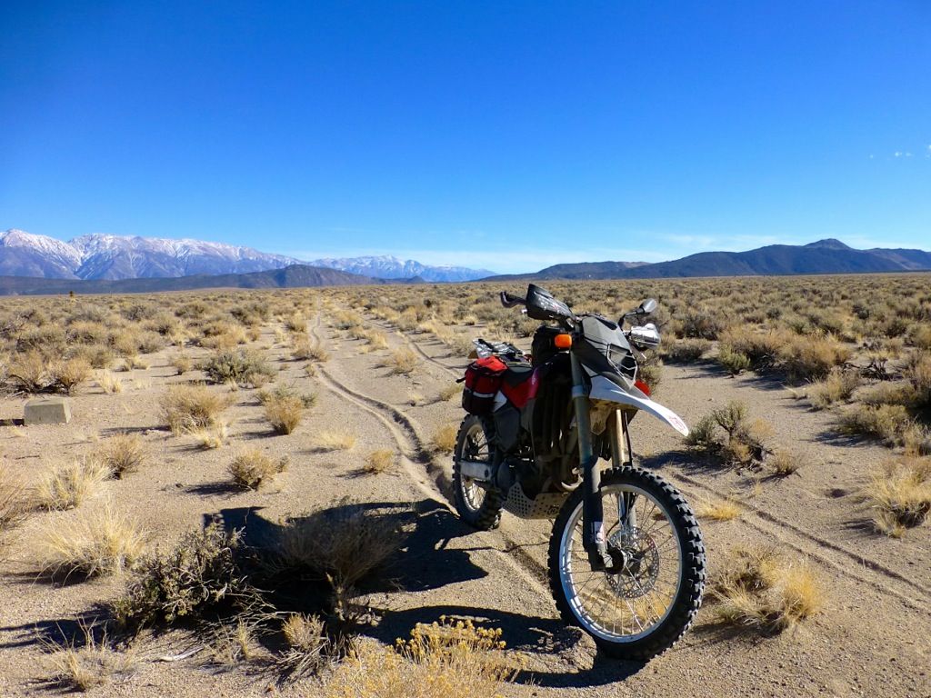
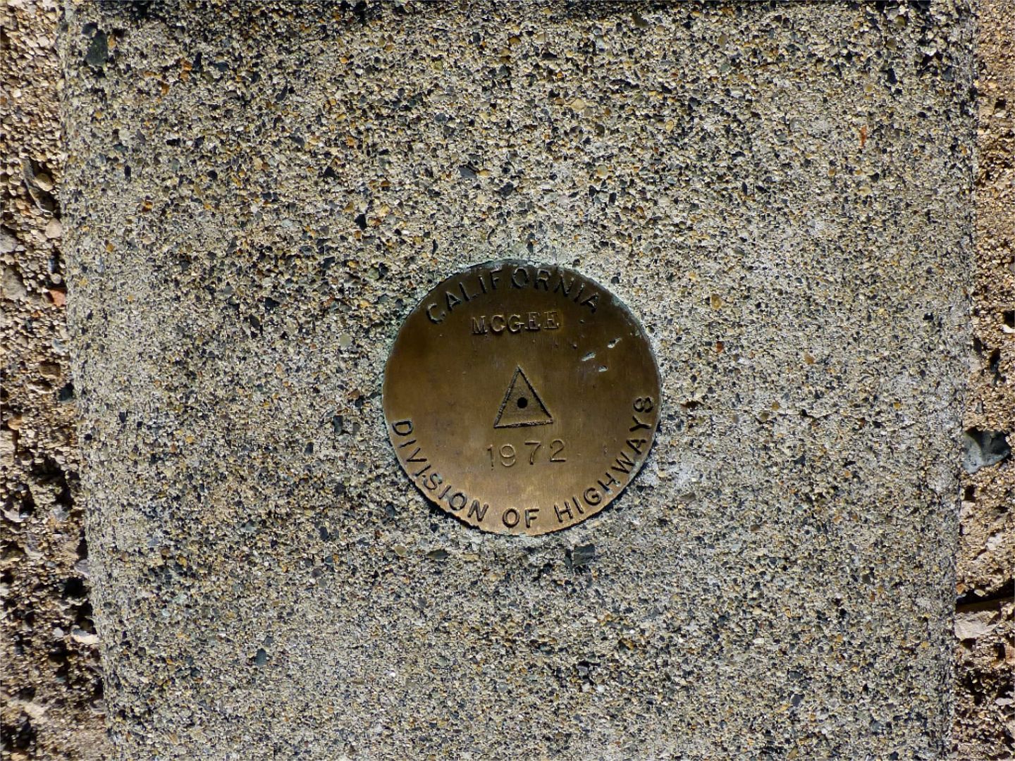
And that's not a USGS marker. I thought it was, and you can see where I was on the brakes (compared to the other track next to me) as I made an unexpected stop to look at it. It's a Division of Highways marker! I've never seen one before…

file_zps0df38eed.jpg


We were actually closer to Black Canyon than McGee Canyon but that's what it said. Those are the White Mountains behind me. And I know all about that sand on the eastern side of Mono Lake. I took my SV out there once :laughing
And only once!


WoodsChick
 
And I know all about that sand on the eastern side of Mono Lake. I took my SV out there once :laughing
And only once!

WoodsChick

Ask Steve (Planegray) about road bikes in the sand on the east side of Mono. :laughing
 
Back
Top