-
There has been a recent cluster of spammers accessing BARFer accounts and posting spam. To safeguard your account, please consider changing your password. It would be even better to take the additional step of enabling 2 Factor Authentication (2FA) on your BARF account. Read more here.
You are using an out of date browser. It may not display this or other websites correctly.
You should upgrade or use an alternative browser.
You should upgrade or use an alternative browser.
Photos of your bike on location
- Thread starter Gary856
- Start date
Gary856
Are we having fun yet?
- Joined
- Apr 6, 2009
- Location
- San Jose, CA
- Moto(s)
- WR250F, MTS1200, 950SM, FZ1, DR650, R1250GS
- Name
- Gary
Alpine Rd last Saturday. Looks like iPhone night shot has its limitation when it's really dark. I was surprised to see a cyclist with a backpack riding up Alpine in the cold, dark night. With no headlight it was hard to see the road. Saw another cyclist riding up Tunitas Creek Rd in the dark a while back. They were nuts.

Gary856
Are we having fun yet?
- Joined
- Apr 6, 2009
- Location
- San Jose, CA
- Moto(s)
- WR250F, MTS1200, 950SM, FZ1, DR650, R1250GS
- Name
- Gary
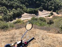
Along Hicks Rd. Both reservoirs looked fairly drained.
Almaden Reservoir


Guadalupe Reservoir

Almaden Reservoir
Guadalupe Reservoir
ThumperX
Well-known member
- Joined
- Aug 26, 2007
- Location
- Off Elk Mtn
- Moto(s)
- Different strokes
Big Bore and little bore Thumpers
- BARF perks
- AMA #: 2817058
Nice shots! Thanks for taking us along by Gary.
N4teTheGreat
FknN8
- Joined
- Dec 5, 2009
- Location
- San Francisco
- Moto(s)
- 2012 DRZ 400s, 2018 Ducati Hypermotard SP, 2008 KTM 950 SM
- Name
- Nathan
Night rides on bicycles are fun, but riding without a light seems kinda stupid, I wonder if these riders are commuting home and just didn't consider the impact of the time change.
- Joined
- Apr 4, 2002
- Location
- Menlo Park, Ca.
- Moto(s)
- Keep me rocking life
- Name
- Budman
- BARF perks
- AMA Life Member #203453
Canyon rats taking full advantage of the low water level.
CDONA
Home of Vortex tuning
- Joined
- Jul 30, 2010
- Moto(s)
- Triumph scrambler, TW200, Monkey
- Name
- # 44659
But they taste sooo good, , ,
Gary856
Are we having fun yet?
- Joined
- Apr 6, 2009
- Location
- San Jose, CA
- Moto(s)
- WR250F, MTS1200, 950SM, FZ1, DR650, R1250GS
- Name
- Gary
Rented this Africa Twin Adventure Sports DCT from Daly City. It's surprisingly wide and tall; with 32" inseam I was on tippy toes with both feet down. Loved the DCT - took some getting used to, but it performed flawlessly and beautifully. The bike handled great, sounded great, and had plenty of power for me.
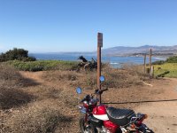
Half Moon Bay airport

Stage Rd, San Gregorio side

Stage Rd, Pescadero side

Half Moon Bay airport
Stage Rd, San Gregorio side
Stage Rd, Pescadero side
Gary856
Are we having fun yet?
- Joined
- Apr 6, 2009
- Location
- San Jose, CA
- Moto(s)
- WR250F, MTS1200, 950SM, FZ1, DR650, R1250GS
- Name
- Gary
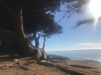
Pescadero Creek Rd


Alpine Rd

Alpine Rd
- Joined
- Apr 4, 2002
- Location
- Menlo Park, Ca.
- Moto(s)
- Keep me rocking life
- Name
- Budman
- BARF perks
- AMA Life Member #203453

That Airstream needs a little polishing

Blankpage
alien
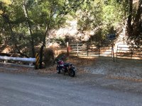
Winterized final ride for the long hibernation until spring.

Blankpage
alien

berth
Well-known member
I like the composition on that one, and the colors, but bike goes well with the building trim.
CDONA
Home of Vortex tuning
- Joined
- Jul 30, 2010
- Moto(s)
- Triumph scrambler, TW200, Monkey
- Name
- # 44659
Backroad Pie run to Cambria, I waited last year to do this until the hills turned green for better pix. It got too much rain and Old Creek Rd to Santa Rosa Creek rd got washed out for the winter. never made a pie run.
This year I didn't wait for the greening of the hills with another sky river due this week. Glad I did, for the road will close for rain damage. Three spots are sketchy now, halfway to total washout, one about four stories deep, sinkhole/creek erosion. Too big/dangerous for a pix to show real size of it.
This spot is where a sulfur spring flows into the main creek, can smell it for a few miles downstream.
Attachments
Last edited:
CDONA
Home of Vortex tuning
- Joined
- Jul 30, 2010
- Moto(s)
- Triumph scrambler, TW200, Monkey
- Name
- # 44659
Old Creek Rd, is faster/smoother now, seems like a back way to Paso/wineries.
Santa Rosa Creek Rd, is more goaty, small patches and tar snakes over the two passes, no help on the last downhill into Cambria, where the big washouts are.
36.8 miles to the north end of Moonstone Beach Rd. from my spot in Morro Bay. I need to check milage from Morro to this spot in Cambria, using Hwy 1, I think 10 miles longer?
This pix has the Castle in it too
Attachments
Blankpage
alien
I like the composition on that one, and the colors, but bike goes well with the building trim.
Photos lose a lot of detail when uploaded to the web compared to original pic
ScottRNelson
Mr. Dual Sport Rider
How did you come up with that idea?Photos lose a lot of detail when uploaded to the web compared to original pic
If you reduce the resolution, yes, the photo loses detail, but if you are able to store it at higher resolution, nothing is lost. I know that Photobucket allows you to store big images if you want, then you can set it up to display it based on how much room there is on screen. Personally, I resize all of mine to 800 x 600 from the original 4k x 3K so they don't take up a lot of storage space. While I'm at it, I crop or straighten the ones that need it.
But photos do not lose detail when uploaded to the web unless you're using a service that resizes them for you. Not all of them do that.

Photo from the past, out in Livermore, just because:

Why did you copy me mang? From 02/16

Photo from the past, out in Livermore, just because:
ScottRNelson
Mr. Dual Sport Rider
Late Fall in Treasure Valley
Random stack of hay bales along the road.

These hills will be at random locations, no idea what made them.

Cows in corn field with pivot irrigation hardware.

Along the Snake River Canyon Scenic Byway. Much less water going down the river this time of year.

This section of road was closed for months. Now it has beautiful pavement and real nice sweeping turns. They should put up a few soft shoulder signs.

Somebody had fun leaving part of their rear tires here.

Random stack of hay bales along the road.
These hills will be at random locations, no idea what made them.
Cows in corn field with pivot irrigation hardware.
Along the Snake River Canyon Scenic Byway. Much less water going down the river this time of year.
This section of road was closed for months. Now it has beautiful pavement and real nice sweeping turns. They should put up a few soft shoulder signs.
Somebody had fun leaving part of their rear tires here.
Gary856
Are we having fun yet?
- Joined
- Apr 6, 2009
- Location
- San Jose, CA
- Moto(s)
- WR250F, MTS1200, 950SM, FZ1, DR650, R1250GS
- Name
- Gary
I resize my photos to 1400 pixels wide in landscape mode to post here. There's certainly some loss of details compared to the full size photos.
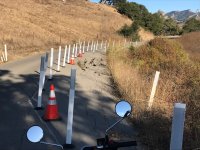
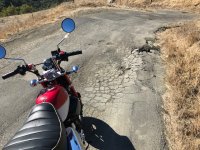
Mt Hamilton.


Haven't been this way in a while; happy to see the repair's done here and the road's open between Quimby and Alum Rock.

Mt Hamilton.
Haven't been this way in a while; happy to see the repair's done here and the road's open between Quimby and Alum Rock.