SFMCjohn
13
- Joined
- Nov 30, 2010
- Location
- San Francisco, 94102
- Moto(s)
- KLR, K75s, TR7V, FXSB
- Name
- John A.
- BARF perks
- AMA #2917550
just getting Palomar Mountain with these links (all appear to be the same link)?
So Cal Classics.
Angeles Crest Google Maps
Mulholland Hwy Google Maps
Highway 33 in Ojai Google Maps
Palomar Mountain Google Maps
Julian, Ca, a popular "destination" ride. Google Maps
Highway 74 Google Maps
Azusa Canyon/Glendora Mtn Road. (I have not ridden this in some time.)Google Maps
Wow...what idiot did these?

 angel
angelSo Cal Classics.
Angeles Crest Hwy 2, La Cañada Flintridge to Wrightwood. Google Maps
Mulholland Hwy, Hwy 1 to Hwy 27/Topanga Cnyn Road. Google Maps.
Highway 33/Maricopa Hwy, Ojai to Lockwood Valley Road. Google Maps
Palomar Mountain, Nate Harrison Grade/Hwy 76 to S Grade Road/Hwy 76. Google Maps
Julian, Ramona/Hwy 78 to Julian, a popular "destination" ride. Google Maps.
Highway 74, San Juan Capistrano to Lake Elsinore. Google Maps
Azusa Canyon/Glendora Mtn Road, Azusa/Hwy 39 to E Fork Road to Glendora Mtn Road/Glendora. (I have not ridden this in some time.)
Google Maps
There, those should work. If you take note of Julian, there's all sorts of bendy roads radiating from it.
I also updated the Ojai map. It still routes around Hwy 33, but it should be obvious the part I'm talking about.


Thanks for all the contributions! Thanks to you, John for updating the OP. I was settling in to do a bunch of work on this today, and you've already done it.

I forgot an important one:
The Center of the Universe. Hwy36 and Hwy3 intersection.
https://goo.gl/maps/me9ciSs4EbfZ9BYVA


Hayfork Bally watchtower …
Cassel, CA. to Fall River Mills. A snake with elevation changes and perfect pavement! Google Map
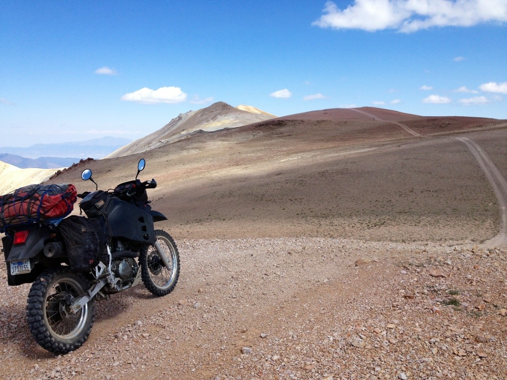
John rocking the dirt.


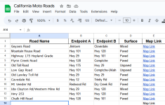
Guasanillo Way - Granite Springs Rd - Blanchard Rd - Marshes Flat Rd., Hwy 132 to Hwy 49, Paved. Google Map
It's paved, but the northern portion is pretty bombed out. Gorgeous countryside with no traffic.
Sorry, been offline for a bit. Traveling mixed with tech issues. Oh well.
Here's a new to me goat trail. I may have ridden it once before with EyeHeartPasta more than a decade back, but I'm not sure. The road name changes.
Guasanillo Way - Granite Springs Rd - Blanchard Rd - Marshes Flat Rd., Hwy 132 to Hwy 49, Paved. Google Map
It's paved, but the northern portion is pretty bombed out. Gorgeous countryside with no traffic.
While we're at it:
Old Toll Rd, Hwy 49 to Hornitos Road. Paved. Google Map
Hornitos Rd. Old Toll Rd to Merced Falls Rd. Paved. Google Map
Merced Falls Rd. Hornitos Rd to Hwy 132. Paved. Google Map
Updated in the OP