-
There has been a recent cluster of spammers accessing BARFer accounts and posting spam. To safeguard your account, please consider changing your password. It would be even better to take the additional step of enabling 2 Factor Authentication (2FA) on your BARF account. Read more here.
You are using an out of date browser. It may not display this or other websites correctly.
You should upgrade or use an alternative browser.
You should upgrade or use an alternative browser.
Photos of your bike on location
- Thread starter Gary856
- Start date
Mellowtonin
Old Enough to Know Better
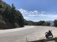
Magic Hour: Mines Road

Put some new shoes on my baby, barely made it to the sunset on Mines Road at 8PM . Confidence inspiring 50/50 Dunlop, I saw about 5 different deer crossing the road on the way back down from the Junction in the dark at 9:30PM

Put some new shoes on my baby, barely made it to the sunset on Mines Road at 8PM
. Confidence inspiring 50/50 Dunlop, I saw about 5 different deer crossing the road on the way back down from the Junction in the dark at 9:30PM
Gary856
Are we having fun yet?
- Joined
- Apr 6, 2009
- Location
- San Jose, CA
- Moto(s)
- WR250F, MTS1200, 950SM, FZ1, DR650, R1250GS
- Name
- Gary
These are some of the most dystopian pictures I have seen of San Jose. Eerie when you add the murals and sculptures of children and development, juxtaposed with graffiti, extreme homelessness, drug addiction, trash and decomposition.
I had to be discrete with the camera, but the plight of homelessness is shocking to see up close. I feel lucky to be able to take a shower at home.
Along Guadalupe River Trail


Sierra Rd

Mt Hamilton


Last edited:

- Joined
- Apr 4, 2002
- Location
- Menlo Park, Ca.
- Moto(s)
- Keep me rocking life
- Name
- Budman
- BARF perks
- AMA Life Member #203453
More beautiful pics Gary. 
Paul that is a sweet shot too.
Paul that is a sweet shot too.
Johndicezx9
Rolls with it...
Hwy 25, near the east entrance of The Pinnacles.

- Joined
- May 2, 2008
- Location
- Stockton CA
- Moto(s)
- 2020 BMW S1000XR Lowride.
- Name
- Bill Harr
- BARF perks
- AMA #: 1097
Sunday PM short ride with daughter to Morgan Territory. Lots of peeps out hiking up here.

A make sure you leave it in first parking job below
Looks like I could get away with saying she was giving the BARF salute here.

A make sure you leave it in first parking job below
Looks like I could get away with saying she was giving the BARF salute here.
Mellowtonin
Old Enough to Know Better
Sunday PM short ride with daughter to Morgan Territory. Lots of peeps out hiking up here...
Ken, did you make a stop at the Junction in front of the mail boxes? My group and I might have waved at you in the afternoon


GB500guy
Member
- Joined
- Jul 12, 2015
- Location
- Vacaville
- Moto(s)
- 1975 Honda CB125S
1989 Honda GB500
1989 Honda NX250
1989 Honda CB-1
1997 Honda CB50V
- Name
- Bill
Wooden Valley Rd. Napa County this Monday afternoon. Beautiful skies and beautiful countryside were a wonderful tonic for the soul.

-Bill
-Bill
Last edited:
Ken, did you make a stop at the Junction in front of the mail boxes? My group and I might have waved at you in the afternoon
Memorial weekend Saturday and Monday on the "freshened up" RZ350. But not last Sunday. And I predict this coming weekend on the RZ again.
2 Saturdays ago
https://www.youtube.com/watch?v=Uo7oXhMobkw
Last edited:
j5m
New member
Colorado:


It's pretty good.
It's pretty good.
Colorado:
It's pretty good.
Great photos. Gorgeous scenery.
Johndicezx9
Rolls with it...
Gary856
Are we having fun yet?
- Joined
- Apr 6, 2009
- Location
- San Jose, CA
- Moto(s)
- WR250F, MTS1200, 950SM, FZ1, DR650, R1250GS
- Name
- Gary
Exploring south/east San Jose


Gary856
Are we having fun yet?
- Joined
- Apr 6, 2009
- Location
- San Jose, CA
- Moto(s)
- WR250F, MTS1200, 950SM, FZ1, DR650, R1250GS
- Name
- Gary
I'm fascinated with riding along train tracks, seeing where they lead to; sort of a forbidden fruit thing. (No, it's not really legal, could be dangerous, so don't do it.)


ScottRNelson
Mr. Dual Sport Rider
The goal of this ride was to find the road from Silver City to Jordan Valley through the tops of the Owyhee Mountains. Google Maps showed a route and I figured my GPS could get me there. I sort of failed at that part, but had a great ride anyway with lots of beautiful scenery.
This is the turnoff from Silver City Rd to F483 (a.k.a., Flint Creek Rd).

For the third year in a row, there are crickets all over the place up in those hills.

They're thick enough in some places that you can't help squishing a bunch of them.

The scenery up there is beautiful once you get up high.

I saw the antenna on the top of this hill, but this side road looked a bit too rough for me riding solo.

On the way back out I realized that there was an easier road up to the top, so I went up there. A couple guys in a side by side were just about to head down. I asked if they knew the name of the mountain. War Eagle Mountain, and that's what Google Maps says it's called as well.

Headed south, snow covered the road in a few spots. Fortunately it was flat enough to work my way around the edge. These are the two worst spots.


Once up high, my GPS got confused and I wasn't sure of the route through to Jordan Valley, so I turned around and headed back out. I didn't want to go back the same way on Silver City Rd, so I headed toward Oregon. However, instead of taking the usual southern route to Jordan Valley, I took the northern split that comes out on Highway 95 many miles closer to home. Heading back into Idaho on Highway 95 there were six separate Owyhee County Sheriff cars running radar. Welcome to Idaho. I just waved at most of them. Two were busy writing tickets. I've never seen enforcement there before, but when they do it, they are pretty serious about it.
This is the turnoff from Silver City Rd to F483 (a.k.a., Flint Creek Rd).
For the third year in a row, there are crickets all over the place up in those hills.
They're thick enough in some places that you can't help squishing a bunch of them.
The scenery up there is beautiful once you get up high.
I saw the antenna on the top of this hill, but this side road looked a bit too rough for me riding solo.
On the way back out I realized that there was an easier road up to the top, so I went up there. A couple guys in a side by side were just about to head down. I asked if they knew the name of the mountain. War Eagle Mountain, and that's what Google Maps says it's called as well.
Headed south, snow covered the road in a few spots. Fortunately it was flat enough to work my way around the edge. These are the two worst spots.
Once up high, my GPS got confused and I wasn't sure of the route through to Jordan Valley, so I turned around and headed back out. I didn't want to go back the same way on Silver City Rd, so I headed toward Oregon. However, instead of taking the usual southern route to Jordan Valley, I took the northern split that comes out on Highway 95 many miles closer to home. Heading back into Idaho on Highway 95 there were six separate Owyhee County Sheriff cars running radar. Welcome to Idaho. I just waved at most of them. Two were busy writing tickets. I've never seen enforcement there before, but when they do it, they are pretty serious about it.
- Joined
- Apr 4, 2002
- Location
- Menlo Park, Ca.
- Moto(s)
- Keep me rocking life
- Name
- Budman
- BARF perks
- AMA Life Member #203453
Living good Scott 
- Joined
- May 2, 2008
- Location
- Stockton CA
- Moto(s)
- 2020 BMW S1000XR Lowride.
- Name
- Bill Harr
- BARF perks
- AMA #: 1097
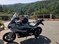
My new XR taking a break at 8,000 feet after some great throttle therapy. Big brother GS to the right.

Note, both bikes just a month old. Some of us Barfers are doing our part to kick start the economy.
Note, both bikes just a month old. Some of us Barfers are doing our part to kick start the economy.