-
There has been a recent cluster of spammers accessing BARFer accounts and posting spam. To safeguard your account, please consider changing your password. It would be even better to take the additional step of enabling 2 Factor Authentication (2FA) on your BARF account. Read more here.
You are using an out of date browser. It may not display this or other websites correctly.
You should upgrade or use an alternative browser.
You should upgrade or use an alternative browser.
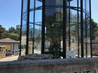
Photos of your bike on location
- Thread starter Gary856
- Start date
Johndicezx9
Rolls with it...
Twas a nice day today...

CDONA
Home of Vortex tuning
- Joined
- Jul 30, 2010
- Moto(s)
- Triumph scrambler, TW200, Monkey
- Name
- # 44659
CDONA
Home of Vortex tuning
- Joined
- Jul 30, 2010
- Moto(s)
- Triumph scrambler, TW200, Monkey
- Name
- # 44659
CDONA
Home of Vortex tuning
- Joined
- Jul 30, 2010
- Moto(s)
- Triumph scrambler, TW200, Monkey
- Name
- # 44659
Blankpage
alien
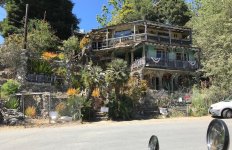
Is that place up to code?
Johndicezx9
Rolls with it...
Didn't Norman Reedus give a tour of that house on his "Ride" TV show?
Edit: Camp Nit Wit, yup.
Edit: Camp Nit Wit, yup.
Last edited:
Gary856
Are we having fun yet?
- Joined
- Apr 6, 2009
- Location
- San Jose, CA
- Moto(s)
- WR250F, MTS1200, 950SM, FZ1, DR650, R1250GS
- Name
- Gary
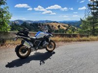
Upper Zayante Rd
I'm usually not bothered by tar snakes, but it's slippery when they smear it across the whole lane like this. Got to be extra careful when wet.


E Zayante Rd


I'm usually not bothered by tar snakes, but it's slippery when they smear it across the whole lane like this. Got to be extra careful when wet.
E Zayante Rd
Gary856
Are we having fun yet?
- Joined
- Apr 6, 2009
- Location
- San Jose, CA
- Moto(s)
- WR250F, MTS1200, 950SM, FZ1, DR650, R1250GS
- Name
- Gary
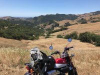
Swanton Rd


Gazos Creek Rd

Lobitas Creek Cutoff

Verde Rd

Gazos Creek Rd
Lobitas Creek Cutoff
Verde Rd
Lonster
GaMMa RaNGeR
- Joined
- Jan 21, 2003
- Location
- The Emerald Triangle
- Moto(s)
- 1986 RG500 Gamma, 2020 KTM 890 Duke R, 1975 RD400 AHRMA Special, 1975 CB350f
- Name
- Lonster
- BARF perks
- AMA #: 305491
Blankpage
alien
No wheelies in front of the popo. What a bummer 

Johndicezx9
Rolls with it...
Done in by a stealth car?
Blankpage
alien
Yeah and I would have spotted it as one had I looked around first. Cop was behind one car in the adjacent lane. Light changed and I wheelied through an intersection, 1st gear nothing crazy then slowed to the speed limit. She may have been waiting to see if I was going to run, don't know. I pulled over and got off soon as the light came on a block behind me.
She gets out of the car an immediately tells me she'll give me a break and won't impound the bike if I have a clean record. I have a riding in a bus lane from 3 years ago, guess that was clean enough.
The offense written on the ticket is Unsafe Start which is a big break from what it could have been.
ScottRNelson
Mr. Dual Sport Rider
I've been trying to find out how far you can get from Silver City toward Jordan Valley. Others in the area have made it clear that even though the maps show roads, it's closed part way through. So my goal was to find out how far you could get before coming to a locked gate. Now I know.
The start of Road F483, Flint Creek Rd.

At the top of War Eagle Mountain. You can see the whole valley where we all live from up here.

Continuing on 483, up at the top. This little bit of easy stuff was a bit of a rest before the steeper and rockier parts.

According to Google Maps, this is Hayden Peak. There is a road to the top, I decided to try to ride up there.

Road 494 heads up Hayden Peak. This is after I turned around because it's just too steep and rocky. Less steep or less rocky would have been okay, but I would have had to just fly up the road and the bike doesn't want to steer on loose rocks like this. It's between 15 and 20 degrees of angle all the way up - steep enough that if you lose momentum you can't get going again. Maybe I could make it on a bike about 200 pounds lighter.

Seven or eight miles in is this warning sign. Clearly marked for sure.

It was actually 1.3 miles from the sign that said it was one mile ahead. This is as far as you can go on this road. I figured it was about nine miles from Silver City Road, but Google Maps says 8.4.

On the way back out I stopped for lunch at this nice view spot.

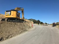
They're doing some road work on Silver City Road. Apparently they're digging up all of the rocks that stick up above the road surface from an inch to six inches. I caught them on their lunch break coming back down, had to squeeze past them headed up.

The start of Road F483, Flint Creek Rd.
At the top of War Eagle Mountain. You can see the whole valley where we all live from up here.
Continuing on 483, up at the top. This little bit of easy stuff was a bit of a rest before the steeper and rockier parts.
According to Google Maps, this is Hayden Peak. There is a road to the top, I decided to try to ride up there.
Road 494 heads up Hayden Peak. This is after I turned around because it's just too steep and rocky. Less steep or less rocky would have been okay, but I would have had to just fly up the road and the bike doesn't want to steer on loose rocks like this. It's between 15 and 20 degrees of angle all the way up - steep enough that if you lose momentum you can't get going again. Maybe I could make it on a bike about 200 pounds lighter.
Seven or eight miles in is this warning sign. Clearly marked for sure.
It was actually 1.3 miles from the sign that said it was one mile ahead. This is as far as you can go on this road. I figured it was about nine miles from Silver City Road, but Google Maps says 8.4.
On the way back out I stopped for lunch at this nice view spot.
They're doing some road work on Silver City Road. Apparently they're digging up all of the rocks that stick up above the road surface from an inch to six inches. I caught them on their lunch break coming back down, had to squeeze past them headed up.
- Joined
- Apr 4, 2002
- Location
- Menlo Park, Ca.
- Moto(s)
- Keep me rocking life
- Name
- Budman
- BARF perks
- AMA Life Member #203453
You guys are living the good life! 
ScottRNelson
Mr. Dual Sport Rider
I miss being able to arrange for other people to ride with. BARF was good for that most of the time. I think my next ride will be all pavement after struggling with some of those steep rocky roads.You guys are living the good life!

Gary856
Are we having fun yet?
- Joined
- Apr 6, 2009
- Location
- San Jose, CA
- Moto(s)
- WR250F, MTS1200, 950SM, FZ1, DR650, R1250GS
- Name
- Gary
I think my next ride will be all pavement after struggling with some of those steep rocky roads.
The unpredictable difficulty level of unknown dirt trails on a 500-lb bike stresses me out. I've sort of lost my appetite for it.
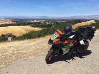
Mt Hamilton, of course.


Last edited:
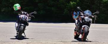
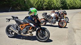
ThatGStig
Member
Just a couple Duke's and a Tuono at the Burger Bar today.
Man, this 890 is fun!
We rode past the burger barn friday, I felt guilty for not stopping
Tacky1
Well-known member
- Joined
- Jul 24, 2002
- Location
- By the ocean....
- Moto(s)
- RZV500 RZ500 RG500
RG500 RZ350 RZ350 RD350LC,
RD350LC CR500AF CR500AF
GPZ750 Turbo
RC30
rgv250
Pescadero Beach yesterday, Did the Alice run and beyond..
