• There has been a recent cluster of spammers accessing BARFer accounts and posting spam. To safeguard your account, please consider changing your password. It would be even better to take the additional step of enabling 2 Factor Authentication (2FA) on your BARF account. Read more here.

Photos of your bike on location

Thx Budman

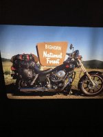
Back when the hair was full and had a red stash n beard! :laughing

(FYI, if you on a mac, click on pic then double tap on pic again and it will go big. Hope that's not too scary! :laughing )
 
From our west coast journey.
Middle of no where Washington.
 

Attachments

  • 6BE7F308-0C44-46B9-8C0A-1AF50B8483E4.jpeg
    6BE7F308-0C44-46B9-8C0A-1AF50B8483E4.jpeg
    93.5 KB · Views: 8
Quimby, Mt Ham, SAV and Mines weren't too bad, and mostly dry. There were thin layers of mud, dirt, debris and water run offs here and there, but the thick mud were scraped off by road maintenance crews.

Kincaid

tafRhrQ.jpg


Starting from the bridge on SAV there were several "road closed" signs. I didn't know why so I pressed on, since I wanted to see where the washed out section is on Mines.

wPEJF3z.jpg


clQulVH.jpg


Turned out the SAV closure was due to a PG&E crew working to replace 2 poles. They were so nice and courteous - moved 2 trucks and lifted the downed lines to let me go thru. They said they'd let bikes thru, but probably not cars. The downed lines were not live, but they didn't want anyone driving over them to avoid further damaging the insulated wires.

kESM1Q2.jpg


yHRNgVc.jpg
 
Last edited:
The Junction. Looked like Del Puerto Canyon was open, but there were "Road Closed" signs on both Mines and SAV.

MCeraDC.jpg


Mines - 6 miles from the Junction. I didn't see a way to get across this.

W7WkB8L.jpg


M3wsylf.jpg


nE3li0Q.jpg


0rYOefI.jpg
 
Mines, heading back toward San Jose. The bike was already very dirty from the last 2 rides so more mud didn't bother me, but the radiator getting clogged with mud and sand made the bike ran hotter than usual. The temp gauge was showing 9-10 bars out of 12, even in this cool ambient.

I5fpYBY.jpg


SAV. I was wondering if the PG&E crew would work past dark. Turned out they expected to be there till at least mid-night; had to get it done. They'll also work on Saturday and Sunday.

mmPopQT.jpg


AUQrjfg.jpg


Mt Hamilton. Something was going on. (I didn't see anything but I'm guessing someone ran off the road.) A ranger parked on the road with his emergency lights on. Further down, 3 big fire engines, 2 ambulances and 1 CHP SUV were all headed uphill with all their lights ablaze.

This was at a road work stop past Quimby, going toward Alum Rock. These big fire engines are so long and wide they straddle the double-yellow in the tight sections; pretty annoying to see as I followed them down the hill for a while. I'd hate to come around a corner face-to-face with one of them, which I have in the past in this very same section of the road.

xF5wLdt.jpg


BNCCLA5.jpg
 
Last edited:
Mines - 6 miles from the Junction. I didn't see a way to get across this.


I dunno looks rideable, you just gotta come in with a little speed, wheelie into the colvert where that slab of asphalt is and give the throttle a good blip to launch up and over. Make sure you record video :laughing
 
Last edited:
Something's brewing...

picture.php


There's a video going around FB shot in Pebble Beach on 17 Mile Drive, near the Ocean Course of MPCC where the waves are hitting the roadway. One guy, videoing from his truck, was behind a few other cars that were turning around.

"Don't worry, we're in a truck!" he says to his passenger.

The video ended with the truck ending up on its side after getting hit by a massive wave.... :facepalm
 
Gary... I had a feeling you would entertain us with some disaster pics. :laughing :thumbup

Butch and I also had one of the big fire trucks come the other way on Hammie. A OH SHIT!!!! moment for sure.
 
Loving the disaster / weather pics. In my case, no riding means it was time for a new chain and sprockets on the DRZ in my garage.

AL9nZEWMPcTC1yGRH7uXkBrJvT-g-iVTv3yKoKxqrkQUmgenwcv5omuugXIM1CnjYp3aghPdi80uvpbkLz0P76IltXMQCj9nnCSmaUsKbqlbokcvteDWsGCI7x7UkifkdcdzrojeGdMbvDu4QKMq3gSvkzfhMQ=w1000-no
 
Someone should get some pictures of the gap on Mines Rd from Livermore side before I do.

I expected light rain today, but ran into an extended downpour. If I had known I'd have tried out the rain boot covers I bought. My Daytona boots are Goretex lined, but they leaked after a few years. A new pair of water-proof boots would be a better option.

Uvas reservoir

uaNKtwX.jpg


Elkhorn Slough. After this it rained hard on Hwy 1 at Moss Landing, and harder still toward Capitola. I enjoyed it until it got dark, then it was somewhat stressful on Soquel San Jose Rd, Summit, old Santa Cruz Hwy. The visibility was too poor to see all road hazards so it was a bit of a leap of faith type of riding.

WRhnUQE.jpg


YLxeiHx.jpg
 
Last edited:
Window Rock a most unlikely location for this bike

 
If he is he just unloaded cause the bike is spotless.
Even the tires look fresh. Must be a Honda ad :twofinger :laughing
 
If he is he just unloaded cause the bike is spotless.
Even the tires look fresh. Must be a Honda ad :twofinger :laughing

Haha! Dirt don’t stick to Hondas :teeth

The storms down here have also done some damage.This is the road

 
Last edited:
Enjoyed a couple hours of beautiful sunshine, blue skies and a beautiful sunset.

Coyote Creek, Singleton Rd

RO8GOp9.jpg


Coyote Creek, Coyote Ranch Rd

ytkY970.jpg


ePsCBir.jpg


ULwercc.jpg


7DaZa0G.jpg
 
Back
Top