Photos of your bike on location

Quien Sabe Rd

mCzYTYw.jpg

That road is interesting for sure. :thumbup
 
Tried to see the Aurora yesterday, just saw the sunset instead, but having my actual camera on me resulted in a few lucky shots that I tried my hand at combining.

Ridgecrest Drive

AP1GczM2yiVSdMG618TV3ZrFO4SyQLS68VcOD0WM-2ouMC1p7a2Ej13tUcBFqh8wfs1KSfKf9zeBPer2kEq2O-IhjOmM1dQaA74q8GSfMiWGf34LFiCFr4CDwS1StnYJtZWhAZ7T7QOJcVe0AFLcuxFMdbJlCQ=w1033-no-gm


Highway 1

AP1GczOzmQfry4K43M1XjXjISQsromDzh-bN5IJ06EPLTQ5deAzvfE2uT1Ulwb8GX3iXXhril0HwKZ4Gaq2HpLRqApz0uXK-XnAFOJIJl53gXtuKD5LCVl-42p6LjAOIggdx3L7TvriD-5W8o-3Etp7HeZwqCw=w1058-no-gm
 
That second with the lit up guardrail (assume a car passing) is very cool.
 
Thanks, I got lucky with that capture, and managed to combine it with another shot with a better exposure for the sky. And yeah, it was a car passing during a long exposure that lit up the bike and left those tail light trails, worked out nicely.
 
Thanks, I got lucky with that capture, and managed to combine it with another shot with a better exposure for the sky. And yeah, it was a car passing during a long exposure that lit up the bike and left those tail light trails, worked out nicely.


FB2 looks so beautiful in both pictures. :love
 
Tried to see the Aurora yesterday, just saw the sunset instead, but having my actual camera on me resulted in a few lucky shots that I tried my hand at combining.

Ridgecrest Drive

Highway 1

Those 2 shots are extraordinary - right place, right time and right effort coming together - very pretty.


Mt Hamilton

qWvcgk9.jpg


HZEI1TF.jpg
 
picture.php


Stonyford, CA, 4 pm, May 16, 2024. gettin’ ready to hang out with 500 OMC Sheetiron 300 riders tomorrow night at the Rodeo Grounds … :ride
 
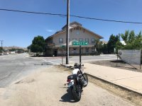
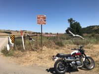
Mission Today, Burger @ Parkfield Cafe, working my way thru San Miguel

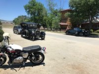
Downtown Parkfield, traffic jam, heavy touring cars out on a jaunt, late starters after lunch. I did take another 7 miles, halfway into Cholame Valley just to see what was there. Large irrigated alfalfa plots, working on winter feed, big money cattle ranching.
As I went on thru Cholame, I imagine the annual tour from Paso, left Parkfield out my direction, so I got to greet the others, (maybe 8 cars), on my return to Parkfield.
Always something more to find out here, as the button says, "Parkfield Magic"

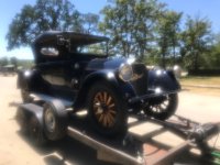
Pierce Arrow on trailer was rescued, first saw it being towed, before the trailer was fetched. Not an artsy "intimate soft focus" shot, but a fingerprint on the lens :teeth
 

Attachments

  • IMG_5908.jpg
    IMG_5908.jpg
    92.4 KB · Views: 2
  • IMG_5911.jpg
    IMG_5911.jpg
    112.7 KB · Views: 2
  • IMG_5913.jpg
    IMG_5913.jpg
    116.7 KB · Views: 2
  • IMG_5914.jpg
    IMG_5914.jpg
    81.4 KB · Views: 2
Last edited:
Maybe my 6th time here, over the years, still fine tuning the property, looking nice after this years; Mothers Day Bluegrass Fest. Weekend.

And the Shakey side, signs at both ends of this bridge, , ,
fully documented, with testing, no doubt about it, a real chunk of the Pacific Oceans' "Ring of Fire".
 

Attachments

  • IMG_5922.jpg
    IMG_5922.jpg
    107.4 KB · Views: 6
  • IMG_5919.jpg
    IMG_5919.jpg
    129.4 KB · Views: 2
  • IMG_5918.jpg
    IMG_5918.jpg
    153.6 KB · Views: 2
  • IMG_5917.jpg
    IMG_5917.jpg
    140.7 KB · Views: 2
Last Week's Ride - go find how high up the snow is

Rest stop at the Osprey nest off of Highway 21 headed toward Idaho City - nest at the top of the dead tree in the background. There are young ones poking their heads up and a parent flying around, but my iPhone is not capable of shooting a decent photo of any of that.
B5w6xNT.jpg


See all of those water filled potholes on the road back there? This road - Grimes Creek - has thousands of them. And you can't miss them all, especially with this kind of tree shadows on much of the road. Still, I thought it was better than riding on the highway to our destination.
45AIHLz.jpg


Another rest stop along Grimes Creek Rd.
2PXJMg9.jpg


The steep road headed toward Scott Mountain with a serious drop off. We're headed up it until we find snow.
RVSQPhF.jpg


Found it. We probably could have ridden a few hundred yards further before the road was totally blocked, but why take the chance of getting to where it would be difficult to turn around?
gkFpfta.jpg
 
This weeks's ride - Prairie, Pine, Featherville, Fairfield

Looking out at the long arm of Arrowrock Reservoir, along the South Fork of the Boise River. It's beautiful this time of year.
VyraKsI.jpg


Beautiful downtown Pine. A gas stop for those with less range than I have.
kpmiGKC.jpg


South Fork of the Boise River, it's full this time of year.
q6dHuOw.jpg


There is still snow up high, we only saw a little of it along the sides of the road.
1ukt9Q6.jpg


My odometer was showing 265 miles since filling up and showed the low fuel warning just a few miles before home. Theoretically I could go 300 miles on a tank, but I don't want to find out that it's really only 299 before it dies. :laughing
 
Grand View to Jordan Valley on Scenic Byway

This ride from Grand View, ID to Jordan Valley, OR along the scenic southern route took us a long way from civilization. This is true middle of nowhere and you wouldn't want to get stuck out here alone. Much of the scenery looked like this. But we "have" to do a ride like this once a year or so.
Rc7CU5u.jpg


Lots of cows out on this ride. Many right along or in the road.
AIMoKp4.jpg


There were miles of cut down trees in piles like this. The way I heard it, these trees were a non-native species with roots that spread out way too far and suck up the water all of the native plants need. So the USFS came through with a bunch of chain saws and cut ALL of them down. Many square miles of tree piles. The green trees in the background are some other variety.
jK9ba3x.jpg


The little sign that you can't read (between my mirrors) in this (small) photo says "North Fork Owyhee Wild and Scenic River". It was about the only seriously interesting scenery on this whole route.
HeRMSPi.jpg
 
top secret location in siskiyou county. IMG_5388.jpeg
 
Back
Top